Yemen’s Disappearing Date Palms: Applied Environmental OSINT
This is an applied case study of environmental open-source investigation on how the war is affecting agriculture and food security in Yemen.
The lush, idyllic region in Hudaydah, on the west coast of Yemen, featuring wadis and fertile valleys, was a place known for its date palm orchards long before a war broke out in 2015. That was the year that Ansar al Allah, better known as the Houthis, an armed group coming from rural areas of Yemen. Years of bloody fighting and a relentless bombing campaign by the Saudi-led coalition ensued to restore the Yemeni government, then led by President Hadi, resulted in the largest humanitarian crisis today. Thousands of civilians are being killed and many more wounded, while millions are displaced by the ongoing war. But it also has wider ramifications, as it includes displaced farmers, damaged water infrastructure, loss of food security, and conflict-affected agriculture. Next to these direct causes, increased droughts and locust swarms also took a toll on Yemen’s agriculture, worsening the food security of millions of people who are now starving or else on the brink of starvation.How severe is the conflict-damage to Yemen’s agricultural industry and how can we know more about what this means for Yemen’s nature, biodiversity, and the people depending on these things?
Going by the latest contribution of the Saudi- and Emirati-backed Yemeni government to the Convention on Biodiversity — in particular its 6th report, submitted in 2019 — the state of Yemen’s environment is grim. Increasing pollution from industrial practices and the dumping of waste water and pesticides is affecting soils, surface and groundwater, with rapidly declining areas for agriculture and climate crisis impacting the land and people who depend on it. Other reports indicate that the limited forestry in the country is declining as desperate Yemenis need firewood due to high fuel price, with an estimated over 800.000 trees cut on a yearly basis. That’s just one of dozens of themes relating to wider environmental issues the report tackles. This is the time to explore links between conflict, environmental infrastructure, natural resources, and livelihoods.
Through online data sources, existing remote sensing analysis, and free satellite imagery we can get a peek at the lesser known consequences of Yemen’s war by visualising this with open-source earth observation data. This article has two parts: The first part is a brief introduction into environmental open-source research, with a focus on data on agriculture changes, damage to water infrastructure, and the consequences for food security in conflict-affected Yemen. The second part will focus on a specific sector, namely date farm plantations in the agricultural rich region of Hudaydah on Yemen’s west coast to see what we can find out about the impacts of the conflict on date production.
This is by no means a comprehensive overview, as there are many complexities related to the agricultural situation pre conflict: these included programs that forced a focus on cash crops to climate crisis factors, as well as mismanagement and wider reverberating effects from past conflicts and policies. Complexities, however, shouldn’t scare interested individuals off from broadening knowledge on this topic.
This article address three key issues:
- Armed conflict can result in direct and indirect damage to water systems and agricultural infrastructure through targeting, displacement, and/or failing environmental regulations. This can severely impact production and thus food security for civilians in and after armed conflicts.
- There is a wealth of open-source information on various aspects of food security, water use, droughts, and wider issues related to environmental conditions that can help researchers and civil society to monitor ongoing risks to food security. UN agencies, international organisations, academic research, civil society reports and open-source investigations provide all bits and pieces of information that can paint a clearer picture of specific environmental security risks.
- Earth observation with various sets of satellites from commercial and public providers was applied to look specifically at the collapse of Yemen’s date plantations in Hudaydah (see image below) governorate. Date palms have been an export commodity and a nutritious fruit, while also providing employment opportunities in the agricultural industry. Open-source reporting indicates that an estimated two out of four million local date palms trees were directly or indirectly affected by the war. Our analysis of three key date palm areas in Hudaydah confirms substantial loss of tree cover and healthy vegetation at these date plantations.
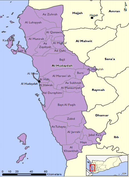
Hudaydah Governorate
Dusting Off The Databases: Where To Look For Relevant Information
Understanding of a region or country where government systems have collapsed has a bad track record on reliable data collection. Yet there are ample resources which can paint a helpful picture of wider environmental conditions, with the caveat that the data is often outdated and/or incomplete. This can always be completed with follow-up, more rigorous scientific analysis or on-the-ground research.
General Information On The Country & Core Data Sets
Humanitarian Data Exchange: Yemen has over a 100 data sets, which can be found here, with key information on population, specific locations, conflict events, and roadmaps, among many other elements. Relevant to our specific topic on the environment, we can also find data using various tags such as “agriculture”, “environment”, “food security”, or “weather and climate”. This provides access to data from the World Bank data set on environmental conditions, though outdated, but also relevant information such as food prices.
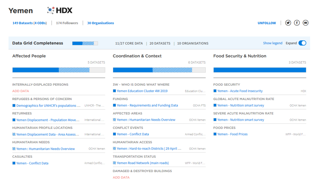
Snapshot of HDX’s Yemen datasets
Food and Agriculture Organization (FAO): This UN specialized organization on hunger has various projects on Yemen and general information that helps build a helpful picture on in-country issues and can be accessed here. This also includes FAOLEX with an overview of all the regulations that officially are put in place, including laws and resolutions of animal species, forestry, environmental laws and water use. FAO also has a web application with all of their statistics and a convenient visualisation tool through FAOSTAT, which provides a quick overview of various indicators relevant for looking into food security issues.
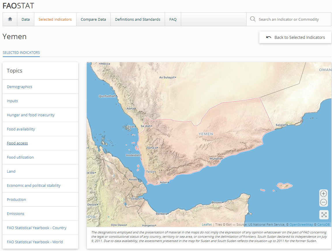
Snapshot of the FAOSTAT website, taken in June 2020
FAO also runs the Early Warning Early Action on Food Security tracker that provides regular updates on state of agricultural production, trade, and prices, as well as provides useful insights on Yemen’s situation. See their latest update from 2020 here.
FAO also runs a monthly updated set of remote sensing analysis of crop production, including data on croplands, drought indexes, and seasonal growth. Even though the level of detail is limited, it still shows certain trends in regions that can be indicative of special events that influence change in crop or vegetation growth.
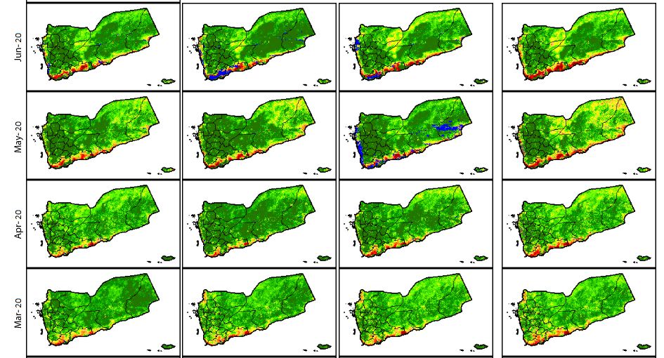
Snapshot of FAO’s Earth Observation site, showing Vegetation Condition Index in Yemen
UN Convention on Biological Diversity (UNCBD): Founded in 1992, this UN Convention has three main coals, namely ‘conservation of biodiversity,; the sustainable use of its components; and the fair and equitable sharing of benefits arising from genetic resources’. In their country overviews, you can find reports submitted by the Yemen government. There latest submission on their work toward upholding the CBD is the 2017 “National Biodiversity Strategy and Action Plan II’, which contains very helpful information on issues around agriculture, forestry and ecosystems in 9Yemen, while their 2019 6th National Report to the CBS has further info progress made to achieve the set CBS goals.
United Nations Development Plans (UNDP). The UNDP is one of the main actors in development programs in the conflict-affected country, stating that its goal is to “assist vulnerable Yemenis to meet their most urgent needs, while also helping to restore livelihoods, strengthen resilience to future challenges, and prepare for long-term development.” UNDP has been criticized by human rights groups and civil society organizations for collaborating with brutal regimes and legitimizing dictators. Having said this, their information can be helpful, albeit potentially biased and not always 100% reliable, as it relies on governments for statistics. Their Yemen page also has some basic data on the country and the projects UNDP implement, which includes work on solid waste management, access to clean water, and clearance of unexploded ordnance. They also publish regular overviews based on in-country research by their own teams, such as this 2019 report, Assessing the Impact of War on Development in Yemen, which has relevant data on water use and agriculture.
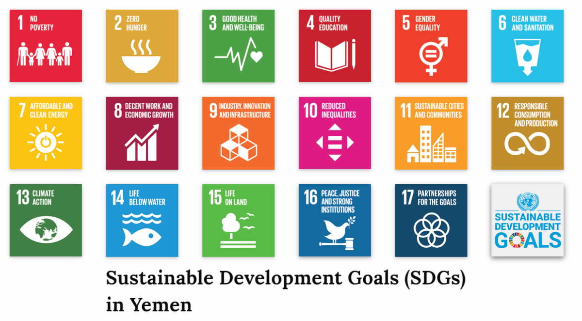
Overview of the Sustainable Development Goals in relation to Yemen
Part of the UNDPs’ work is measuring progress on the Sustainable Development Goals (SDGs). These goals aimed to “address the global challenges we face, including those related to poverty, inequality, climate change, environmental degradation, peace and justice” are captured in 17 categories, including those related to environmental research such as water use, climate, and food. The Yemen page on the UNDP’s website provides quick key data on the progress of achieving those goals.
UNICEF: With a focus on children, UNICEF goals are to provide assistance “including health, nutrition, water and sanitation, education and child protection.” as over 12 million children face direct threats from the conflict. The website provides monthly informative data in their Situational Report
UNOCHA: The UN’s Office for the Coordination Humanitarian Affairs website provides key figures, maps, infographics, and situational reports on various themes including water, sanitation and hygiene, and food security.
The World Bank: Though most of their data is also on the HDX website, their Yemen page provides insight on their project on Yemen. Their strategy plans on investments have valuable information on conflict analysis for specific sectors, including agriculture and issues related to climate security.
World Health Organization: The WHO’s role in Yemen is mainly to provide health support to the government and health authorities. Part of their work is also focussing on malnutrition, which helps gain a better understanding of how lack of food security is impacting the health of Yemeni people. This can be seen through their Nutrition Surveillance Dashboard.
Reliefweb: Another very helpful resource run by UNOCHA that has reports from the UN, international organisations, and non-governmental humanitarian agencies. Its Yemen page has a brief situational overview and all the latest reports and statements on what is happening in the country.
ACLED: The Armed Conflict Location & Event Data Project (ACLED) collects data on conflict events and political violence. Their Yemen page provides insights of the events of the last few years.
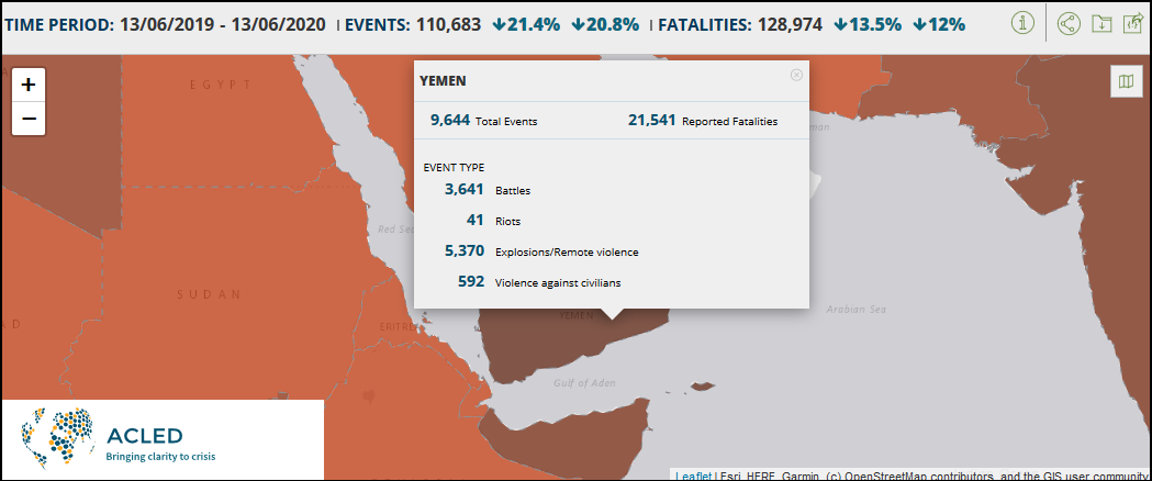
Snapshot of ACLED’s database with reported events in Yemen
Other helpful resources on conflict data is LiveUAMap’s Yemen page, but it requires payment to see historical events. Historical data, though not verified, can be found on Yemen War Archives with information on types of sectors being targeted and their subsequent impact on health, education and agriculture.
Academic literature
Google Scholar is your friend. Often, it has relevant information from specific local or regional issues. For example, a search on “Yemen + Agriculture” gives insights featuring current and past research articles on soil conditions, as well as traditional and modern agricultural methods.
Other Open-source Data Sets
Various initiatives using remote sensing contain information on water, security, weather conditions, and agricultural practices. For example, the World Resource Institute developed the Aqueduct Water Risk Atlas with information on water related issues, e.g. droughts and water flows. The Dutch Ministry of Foreign Affairs published a Climate Change Profile Yemen [PDF] with essential key data on climatic conditions and meteorological information as part of an analysis on changes due to the climate crisis.
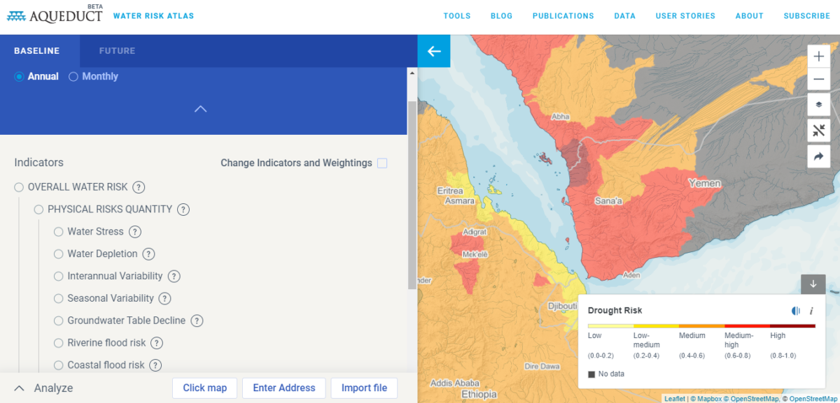
Snapshot of the World Resource Institute’s Water Risk Atlas
The WRI also is involved in the Water, Peace and Security initiative, which provides an open source data platform aiming to predict water-related conflict. When zooming in on Yemen, the map outlines these forecasts:
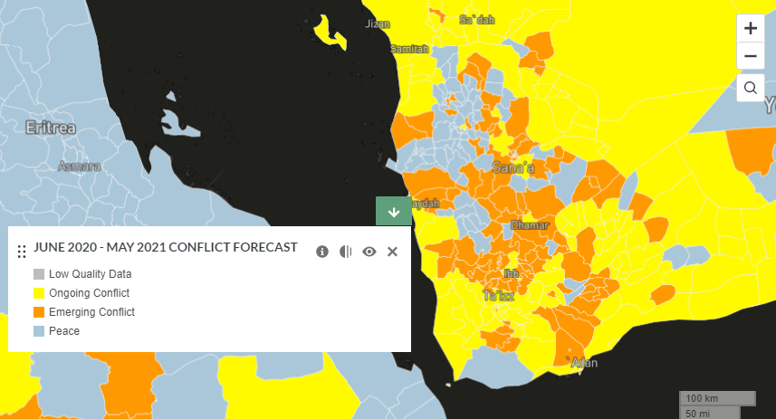
Snapshot of the Water, Peace and Security’s Conflict Forecast
The WRI supported Partnership for Resilience and Preparedness, a project launched in order to deal with climate fragility. Their website can be a very helpful tool, as it has baseline data on various relevant environmental conditions, such as land use, which can be visualized through their data platform.
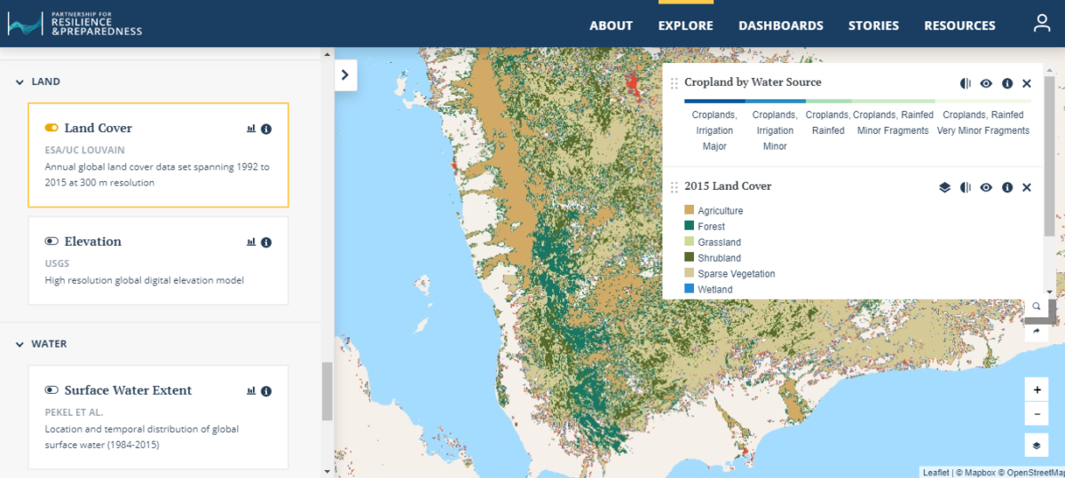
Snapshot of the WPS Climate Fragility data platform showing cropland cover
The Dutch Ministry of Foreign Affairs also published a Climate Change Profile Yemen [PDF]with essential key data on climatic conditions and meteorological information as part of an analysis how this is changing due to the climate crisis.
Other resources include WaterWatch’s project on Yemen, with various spatial analysis posters of water consumption for water agriculture, the USAID funded Landlinks with key data on land use in Yemen, including forestry, water and minerals — though it should be noted that this data is already 10 years old. There was also the Water and Environment GIS Lab based in Sanaa; it is now offline yet still accessible with the Wayback Machine. The World Bank also cooperates with ICARDA for the project known as Geoinformatics for Agricultural Monitoring, which has several GIS Agricultural maps that can be produced via their online Yemen portal. Lastly, there is also the Famine Early Warning Systems Network, set up by USAID, that puts out regular alerts on food security in Yemen.
Snapshot of the Famine Early Warning Systems Network’s Yemen page
To sum it up, there is a wealth of data available that helps to get a sense of the environmental conditions of a country, including land use, water security, climate crisis and various basic data sets on population and infrastructure. With these datasets, you can explore specific areas of interest. For this article we will be zooming on agriculture and how the war and other causes impacted date palms forests.
Farmland Under Fire
The majority of food in Yemen is imported as only a few percent of its land is suitable for agricultural production, in particular due to the lack of water. Agriculture in Yemen is dependent on rainfall and/or irrigation and generating sufficient production been a long standing problem, as the country suffers from water shortages. Unsustainable water extraction and irrigation issues have been compounded with an increase of growth of qat or khat, a local addictive drug consumed by chewing on its leaves and grown as a cash crop.
The databases mentioned previously in this article provide insight into the local agriculture dynamics of the last decade and can help us understand the persistent problems with food security. A WFP report from 2009 flagged problems with hunger, and conflict, which has been an ongoing issue, stating that, “Root causes of food insecurity include: high population growth, reliance on food imports and oil revenues, overexploitation of limited natural resources (namely water) and lack of livelihood diversification options, especially in rural areas. Natural hazards and conflict severely affect food security.”
These historic issues are clearly outlined in a special chapter on Yemen in this Crisis and Conflict in Agriculture publication, explaining that a change in agricultural practices due to oil discovery in the 1980s resulted in cheap diesel becoming available and the use of more unsustainable, water-intensive, and non-renewable production with water pumping systems for Yemeni farmers. When the recent conflict erupted in 2014, this also had further deteriorating effects on agriculture.
According to the Worldbank Group satellite analysis of agricultural lands, there was a 76% decrease in active cropland production through 2014-2017, as visualised below in a series of remote sensing analysis conducted with ICARDA. The report provides very valuable insights and methods on measuring damage to agriculture in Yemen using remote sensing Unfortunately, we haven’t been able to trace a higher resolution version of the map as the data seems to be offline at the time of writing. However, their 2018 report
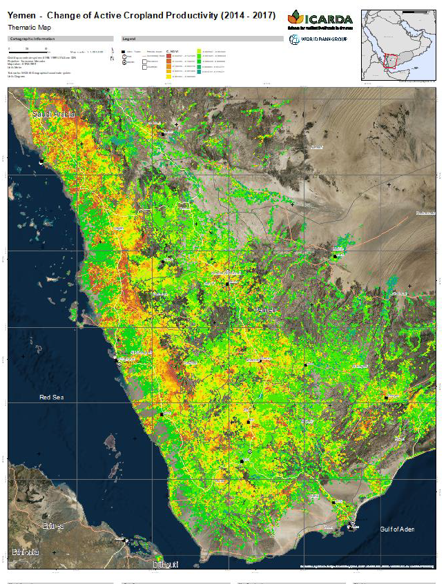
Snapshot of the World Bank’s Earth Observation Analysis of change in crop lands 2014-2017
The conflict contributed to deteriorating agricultural conditions and worsening food security, where the World Bank stated that in 2019, an estimated 24.1 million people — 80% of the population, that is — was “at risk” of hunger and disease, of whom roughly 14.3 million were in acute need of assistance.
Humanitarian aid organisations also raised the issue of food security with the conflict in Yemen. Oxfam’s paper on Missiles and Food from 2017 provides helpful insight on how war tactics and deliberate restriction on import affected food security for the Yemeni people.
Data collected by UNDP in their 2019 report on the impact of the war underscored the impact of the war on agriculture and how this lowered the yield from crops, stating that, “Water scarcity is the most important factor limiting agricultural production and fuel shortages have made irrigation costlier. In 2016, the area cultivated decreased by 38 per cent, on average. In the heavily agricultural Tihama region, all groundwater-related agriculture was suspended, cultivated areas fell to 39 per cent of prewar levels and yields were reduced to 42 per cent pre-war levels. “
In Hudaydah governorate, the area of interest of this article, recent predictions on food security by Famine Early Warning Systems Network are painting a worrisome picture with a general decline in crop production, sales of crops, and diminishing agricultural labor, as well as ongoing high prices for wheat and sorghum.
For farmers, access to agricultural lands is also hampered by landmines and UXOs, as noted by Human Rights Watch in their 2020 annual report. Other reports from ACLED note that these practices of placing landmines and IEDs are particularly rampant in Hudaydah, while Medicine Sans Frontier provides local insight in this 2019 article on the increase of these practices on farmers and their livelihoods.
Water In The Crosshairs
Decline in agricultural production as a result of conflict has several key reasons, including lack of fuel for pumping systems, displacement, and the targeting of water systems. The latter is interesting to focus on for this article as we zoom in more close on our case study.
Attacks on water infrastructure have been lambasted by the UN as “breaching the basic laws of war.” Research by Bellingcat already identified bombed water infrastructure in the early stages of the war. Comprehensive data on specific targeting of wells and water infrastructure is missing, but let’s take a look at what is available.
According to the Yemen War Archives, based on reporting by the Yemeni non-governmental Legal Center for Rights and Development, as of June 2018, thousands of agricultural facilities and water related objects had been targeted by the Saudi-led coalition, though a clear source or methodology is not provided, nor does the website have any recent updates.
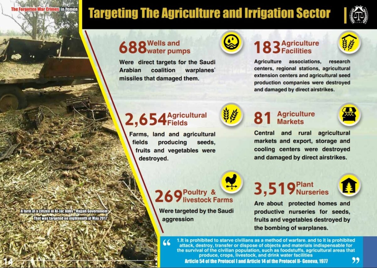
Snapshot LCRD Website of its Yemen data on agriculture
In 2018, the World Peace Foundation published an insightful report, “Strategies of the Coalition in the Yemen War: Aerial bombardment and food war”, outlining how deliberate targeting of agricultural infrastructure and water systems severely degraded crop production, worsening food insecurity. The report includes, using Yemen Data Project’s data, attacks per governorate and district, focusing also on Hudaydah governorate and Tihama’s plains agricultural production, targeted by the bombing campaign.
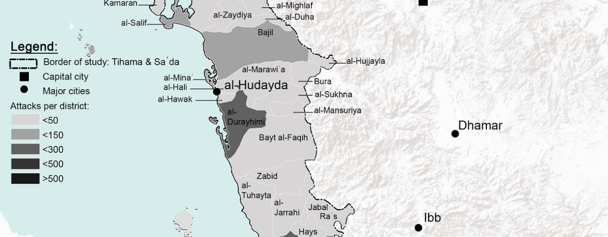
Overview by WPF 2018 report with number of attacks in Hudaydah
With an account to LiveUAMap’s database, one could also track more incidents in areas of interest that are related to water infrastructure — by specifically tracking public reports on social media.
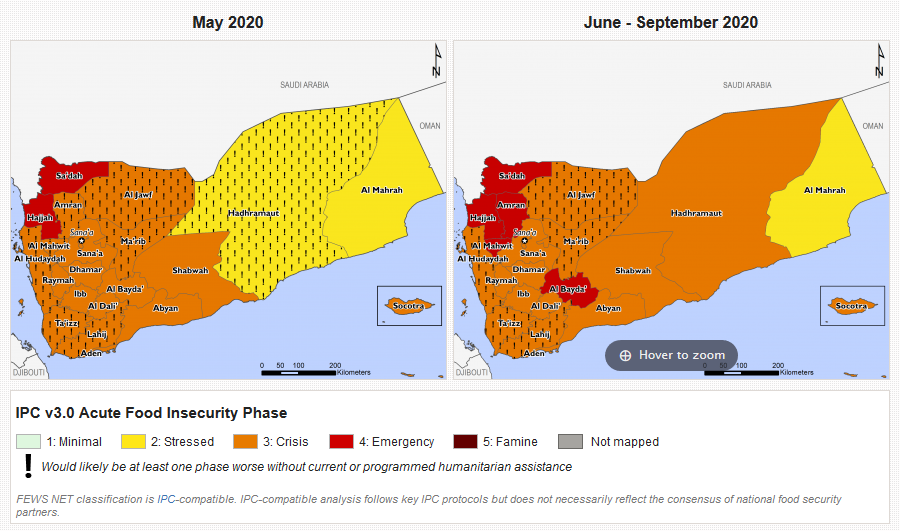
The severity of attacking water infrastructure and wider collapse of access to clean water is reflected in the regular updates found by humanitarian agencies on the Water, Sanitation and Health (WASH) updates, which gives helpful insights on the consequences of the absence of clean water. In the May 2020 update, the UN’s WASH Cluster Desk review stated that, “In 2019, it was estimated that over half of the population (55%) did not have access to safe and clean water, and that almost half (45%) did not have access to soap due to economic reasons. The 2019 Yemen Humanitarian Needs Overview estimated that over two thirds of Yemenis were in need of Water, Sanitation, and Hygiene (WASH)-related assistance, with 12.6 million of those in acute need of support.”
In its 2017 report on WASH services, “Dire Straits, The Crisis Surrounding Poverty, Conflict, and Water in the Republic of Yemen,” the World Bank data demonstrates that the conflict nullified the progress made on improving water security and WASH prior to 2014. According to the report, the conflict damage, ensuing change in power relations, the humanitarian crisis, and increased drought will pose severe challenges for the future of the country that needs urgently addressing.
In conclusion, there are various tools and reporting mechanisms that are currently tracking specific targeting practices and impacts, though not all have clear references and data sets that are available for verifying claims. Yet the impact of attacking water infrastructure and related services is clear from the various figures given by UN and humanitarian organisations. Agricultural production, already under stress from lack of water prior to the conflicts, did decline overall, based on current analysis by the World Bank, FAO, and WFP. Though Yemen mostly relies on import for food, any loss of production will only add to worsening levels of food security and growing malnutrition.
On Khat & Agriculture
Lastly, one other problem in Yemen is the widespread use of khat (or qat), derived from the Catha Edulis plant. Chewing the leaves gives the user an euphoric high, and has been a tradition for centuries in the Yemeni highlands. This practice has spread rapidly over the last decades, with current estimates that over 90% of local men and 50% of women chew the leaves. Qat growth is spread throughout agricultural areas, including Tihama plains, but is mostly located closer to the mountains due to higher altitude and better climatic conditions.
Apart from societal and health impacts, the increase in the use and subsequent growth of this cash crop also has consequences for food security. The cultivation of the plants is estimated to take up 38% of all the water use by farmers, and 60% of newly cultivated land is dedicated to growing khat. These are significant numbers in terms of water and land use, which take away valuable resources to grow food. This phenomenon should be part of any analysis on food security in Yemen. Ongoing initiatives are currently attempting to shift khat farmers to coffee as a cash crop.
Case Study: Tihama’s Disappearing Date Farms
For this specific case study, we will investigate the impact of food security in one of Yemen’s most agriculturally rich areas. The best way to understand is use the words of Yemenis themselves, which is why we asked our Yemeni colleagues from Mwantana for Human Rights, a Yemen-based organisation with a wide network of researchers, for a brief overview. They provided the following history of the Tihama Plain and its struggle:
“On the western coast of Yemen, Tihama Plain extends as one of the most fertile agricultural lands in the country. This plain contains the vast farms of dates, mangoes, bananas, cotton, millet, corn, wheat, papaya, and watermelon, which are surrounded by luxurious palaces with elegant pools and precious stables. Besides these luxury scenes, you can see shabby cottages strewn over the plain inhabited by tens of thousands of oppressed who were marginalized by the laws and policies of successive regimes that exist since the beginning of the last century. when people of Tihama refused to accept the absolute theocratic authority of the ruler at that time, who launched against them a war that lasted for years and ended in deprivation of their liberty and their land, as eloquently described by Fred Haliday in his ‘Arabia without Sultans (1974,pg. 86-93)
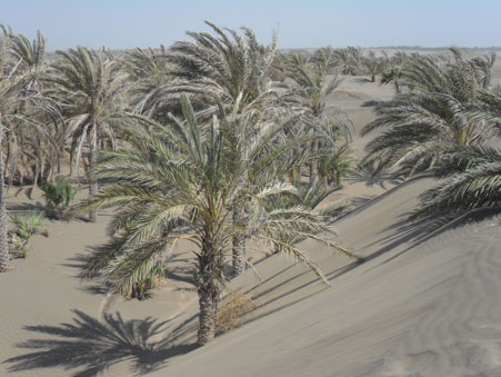
Desertification affected date plantations in Tihama, by Wahib Al Qubatee, University of Wageningen
After that war, successive governments maintained the conditions of humiliation and impoverishment against the people of Tuhama. Looting of agricultural land increased by military and political leaders, tribal and religious sheiks, and merchants. In a 2010 parliamentary report, 148 people, some of whom are members of Parliament, businessmen and military and security leaders, officials and sheikhs were accused of seizing lands belong to the state and citizens in Hudayadah governorate: To the extent, some feudal lords use peasants as forced laborers, in a scene reminiscent of the serfdom system in pre-modern times. Only this current war, which exacerbated the conditions of misery, hunger, and humiliation, pushed the images of the people of Tihama to light.”
This disturbing overview of the region’s history is helpful to understand the current dynamics on conflict, agriculture, and food security. Our specific interest in date palms was sparked by an article published in 2019, titled “The death of a million Palm trees”, which provides more background and insights in the locations and implications related to the loss of the date trees in wartime Yemen, in particular the agricultural areas on Tihama’s plain in the Hudaydah governorate. For this research, we will focus on various locations mentioned in the article and try to see what kind information we can find, while applying earth observation tools via ESA’s Sentinel-2 satellite imagery, available via Sentinel Hub’s EO Brower, and Planet Labs Explorer satellite imagery.
The growth of date palms, Phoenix dactylifera L. in Latin, is an important aspect of food security. The dates are a fruit with a high nutritional value, and the practice of date palm farming that has been part of Yemen’s agriculture for centuries, if not longer. There are several sources that are helpful and are accessible directly online with information on Yemen’s date trees. The most up-to-date source we could find was the Global Forest Resources Assessment 2015 report by FAO, noting that Yemen has 34.526k of hectares of date palm agriculture and 5.181k hectares of cultivated date palms. Another publication by the University of Aden from 2015 stated that Yemen had over four million date palms in the period 2008-2012, producing roughly 58.000 metric tons of dates, also noting that in Hudaydah, there are 59 different date palms cultivars. Hudaydah ranks second as the largest data palm grower, while the Hadhramaut governorate in east Yemen being the largest producer.
Date tree farming is an intensive process, as farmers need proper water infrastructure, not to mention knowledge on dealing with the many insects and diseases often found in date trees. Reports from 2015 already indicate growing threats from pests such as the red palm weevil and restricted access to pesticides, and, more recently, swarms of locusts threaten agriculture, including date farms.
After the war broke out in 2014, the ongoing hostilities also had consequences for the date farms. Open-source reporting helps provide insight into the struggles of the farmers and understanding what results in the loss of date forests. These concerns were already raised in 2016 as drought, desertification, and lack of irrigation threatened the date palm production in the Tihama Plain.
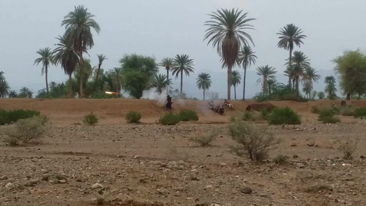
Tihama Resistance fighters clashing with Houthis in southern Hudaydahm, December 2017. Img via Twitter user @demolinari
In this article by Al Jazeera from 2018, a farmer explains the impacts as, “there are some farmers who lost their farms completely, especially those located in the battle lines, and there are those who lost large parts of them and were unable to harvest their fruits, because the fire and the bombing prevented them from reaching their farms to harvest the crop”
Apart from the impact of armed conflict, the lack of diesel for the water pumps also had a negative impact on irrigation, which led to further desertification and loss of date trees in the area. Meanwhile, lack of rain, sinking groundwater levels, and sand dune movement weer already a problem that impacted the date tree farming prior to the war, as per this academic research paper.
Date Farms On The Tihama Plain
Due to the problems with access to water and lack of investment, up-stream date palm production is not considered profitable for farmers on the Tihama plains, according to this 2019 research, which is focussed on Wadi Zabid. The article also explains why there are more date palms downstream near the coast, where groundwater levels are higher.
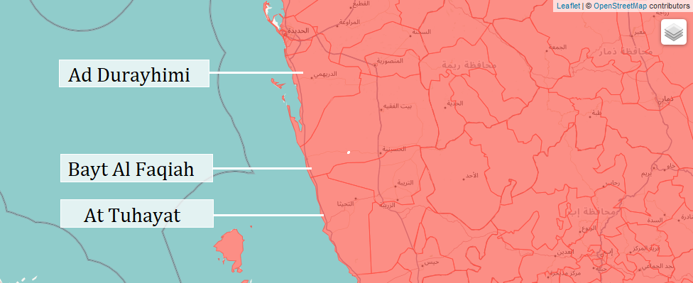
The earlier mentioned article that inspired this article refers to Al-Tahita, Al-Duraimi, and Beit Al-Faqih in the Hudaydah Governorate. With the Humanitarian Data Exchange datasets on Yemen, we can easily locate the different directorates online, though you can also download the shapefiles and load them into your GIS program or Google Earth Pro. One of the three districts on the coast is actually named At Tuhayat, whereas the article mentioned Al-Tahita, a town in this district.
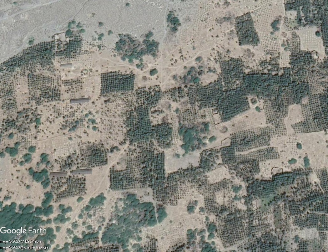
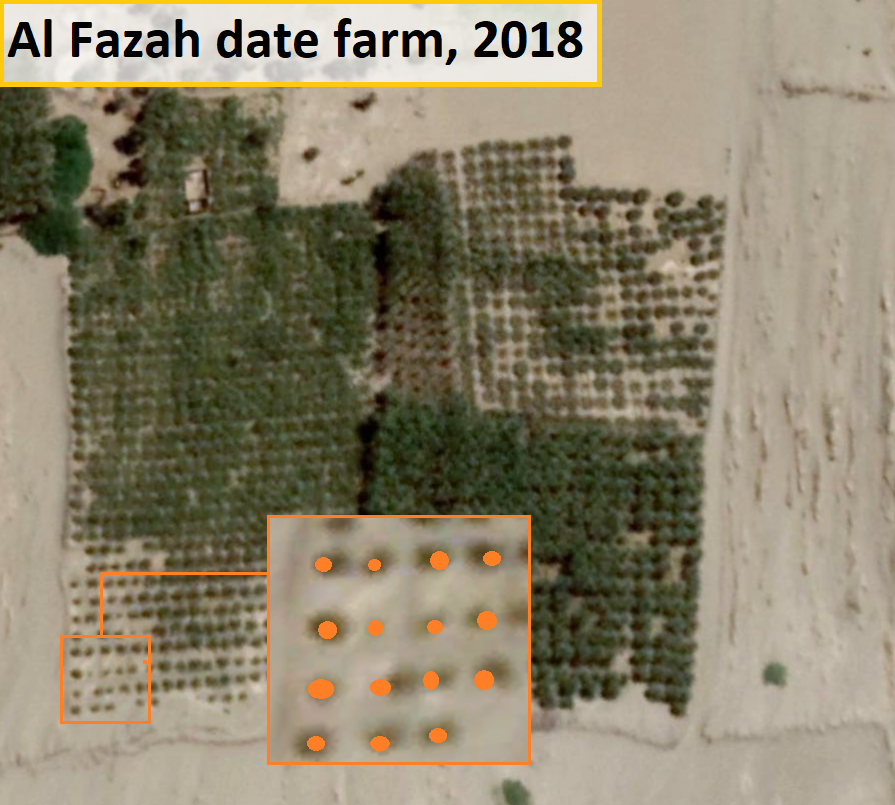
Using this information, we can look for areas with the data palm plantations, which are fairly easy to recognize by the way they are planted in long rows and squares. We found useful information on the set-up of date palm plantation in a 2008 workshop on “Irrigation of Date Palms and Associate Crops”, where the Yemeni submission stated that “It is estimated that 12.8kg/palm tree are produced on modern farms using 8×8m tree spacing. Old farms based on 5×5m spacing only produced around 4kg/palm tree.” These plantations can be easily spotted with satellite imagery on Google Earth, with example below at a major date plantation area south of Hudaydah, close the the town of Al Jah al A’la
Zooming in on one date farm north east of Al Fazah in the At Tuhayat district, we see this one has an average of 16 to 20 trees per 400m2, as measured using Google Earth Pro. Though likely varying a bit, as it depends on tree size and land, such numbers, give or take a few, can be used as a rough rule of thumb to calculate the size of a plantation in a certain area. Counting all of this would be a significant task that we won’t pursue for this article, but with time and resources it would be possible to track the amount of trees lost in specific areas.
We have also researched the possibility of other tree plantations being used, but have not come across any information of other types of large trees that will take up this amount of space in this area. The Tihama plains are known to have banana plantations, though their planting structure takes up a much smaller footprint in terms of spacing than date palms. This makes it unlikely that the locations identified with optic imagery and visual IDs of the structure are banana plantations. Moreover, their numbers have been winding down already before the conflict as they require even more water. Consultation with Yemeni partners and experts yielded similar conclusions.
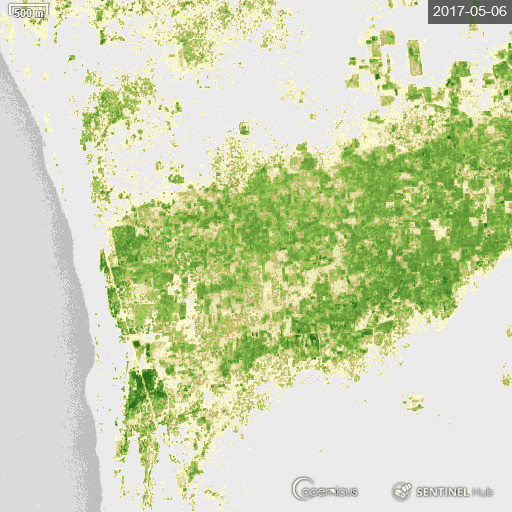
Going through Google Earth Pro high-resolution satellite imagery of these areas, we can then identify in which area most of the date farms are located. We can use Sentinel-2 imagery with Short-wave Infrared Index for contrast to show which areas have numerous date plantations, going by the vegetation of areas near the coast. Below is a satellite image of the coastal area with green, indicating the vegetation cover, and we use Google Earth Pro to zoom in on the coastal areas and find date plantations. This resulted in a focus on the following three key areas:
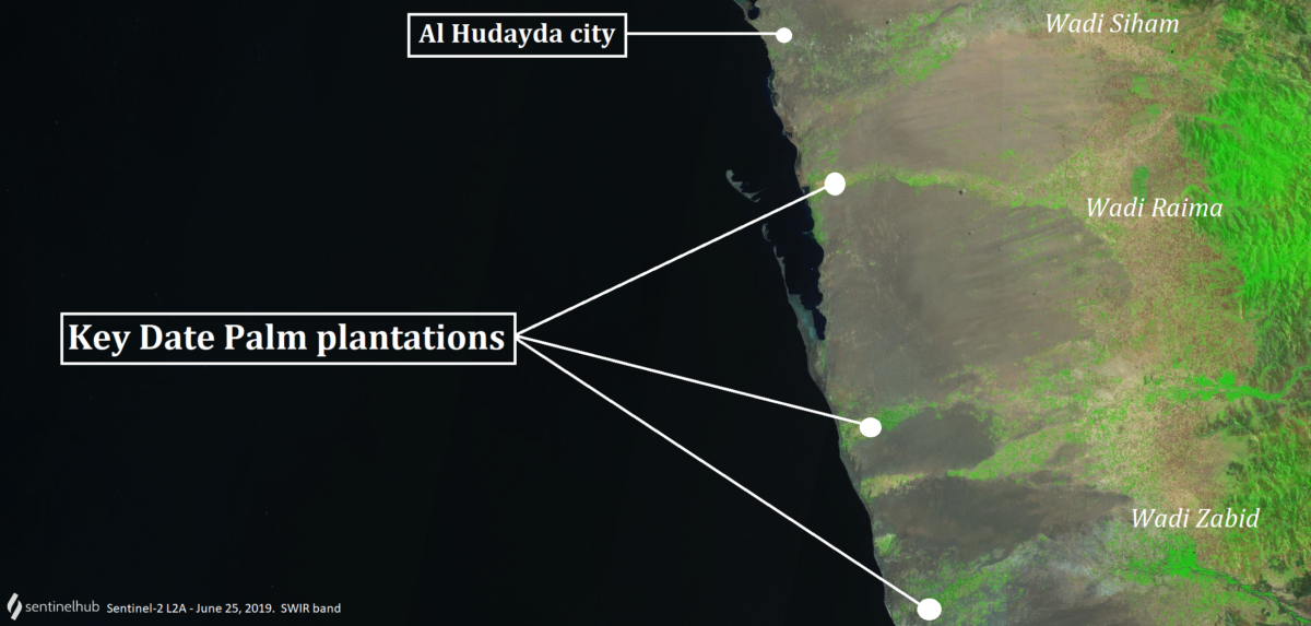
Key date plantations on the west coast of Yemen
Now we know where the locations are, we can now use to see if there is a change in vegetation growth over time. Google Earth Pro does have satellite images from before and at the beginning of the conflict in 2015, and the latest imagery is from February 2020 in some areas we are looking at. Indeed, as shown in the image below, we clearly see date trees disappearing in large numbers, with entire fields going dry. Using both Planet Labs imagery and Sentinel-2 timelapse we will look at each of the three areas.
Though these images are indicative of change, one has to be careful, as absence of clear imagery of leaves on the trees could also be a result of seasonal change or light conditions during the time the satellite image was taken. Therefore, we can also use the Timelapse function in Sentinel Hub’s EO Browser, with the Normalized difference vegetation index (NDVI) that, as explained by Earth Observation System, is “a measure of the state of plant health based on how the plant reflects light at certain frequencies (some waves are absorbed and others are reflected).”
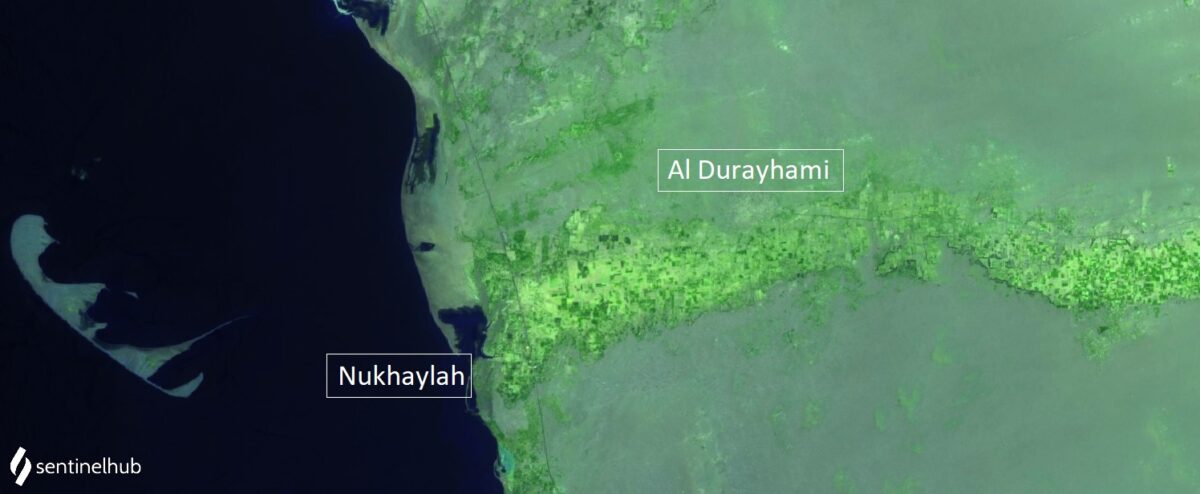
Ad Durayhimi
The date plantations near the coast are at the end of the outflow of the Wadi Raima. In the Holmakhdar report on the dying date trees, the village of Al-Nakhila is mentioned, which is a coastal village and can be found on an UNOCHA map of this governorate via Reliefweb.
Sentinel-2 L1C Vegetation Index, July 3, 2020
According to a source in the article, this area once had over one million date palms flowering, though this was in better times, years before the conflict with the Houthis erupted. A quick social media scan in Arabic helps finding relevant information, and we learn from a news report that the area was hit in 2016 by a hurricane that damaged many date plantations. Al-Nakhila is also featured in a regional news item on Yemen Today, mentioning desertification and how it impacts the date plantations, while another report from end of 2019 shows cut date trees at the plantations in this area. At the time of writing of this article, the conflict tracking website LiveUAMAP shows that part of the date plantations land inwards are under control by the Houthis (in pink), while the area at the seaside is back under control of the Saudi-supported Yemeni government forces (in blue).
Snapshot of LiveUAMap.com’s Yemen page showing the frontlines
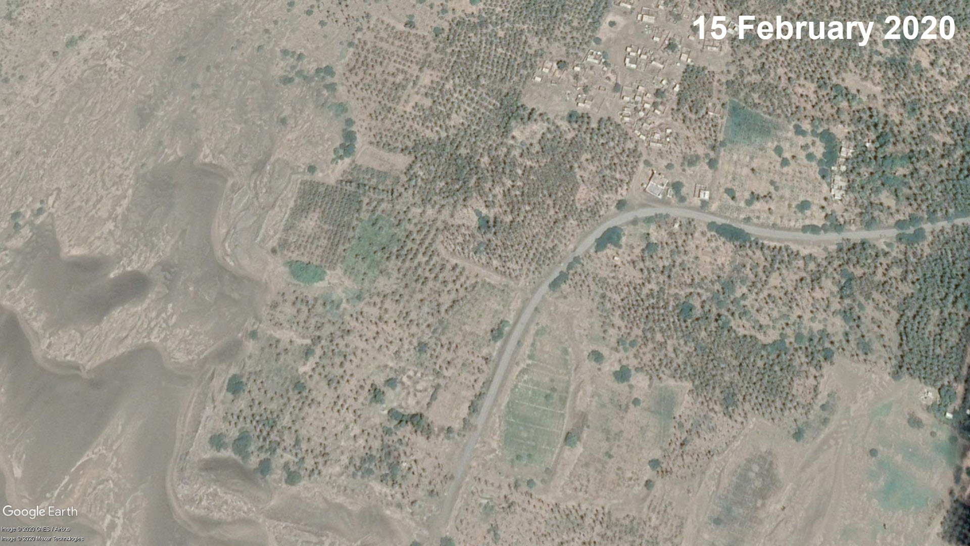
Close to the sea and across the N2 highway to about 7km land inwards, there is a large agricultural area of roughly 20km that contains major date plantations. After that, it seems mostly other types of crops are being grown. We noticed the largest visually confirmed loss of date palms plantation around the village of Al Hiddah, captured here on Planet Labs imagery using near-infrared bands to show healthy vegetation.
(Source: Planet Labs)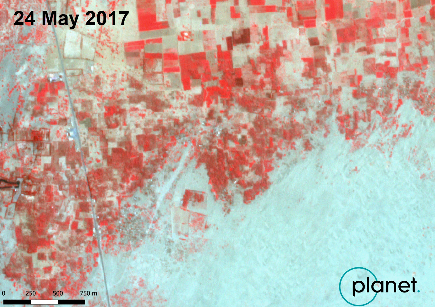
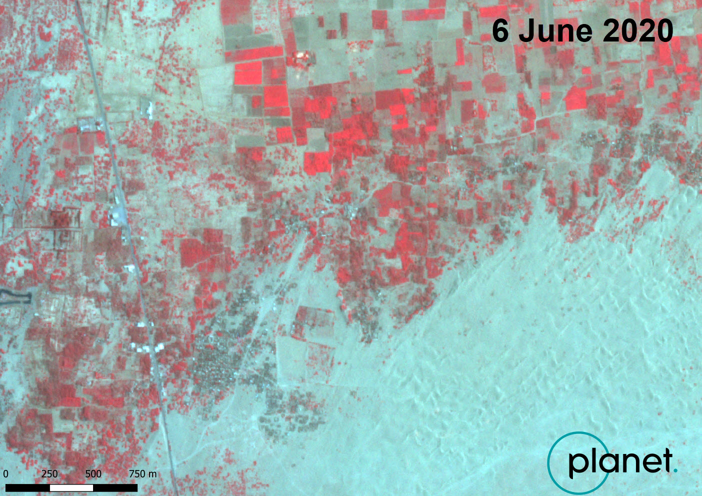
We can clearly see the overall loss of date growth in the centre of this area, and using Google Earth Pro we can also look at a more detailed level:
(Source: Google Earth)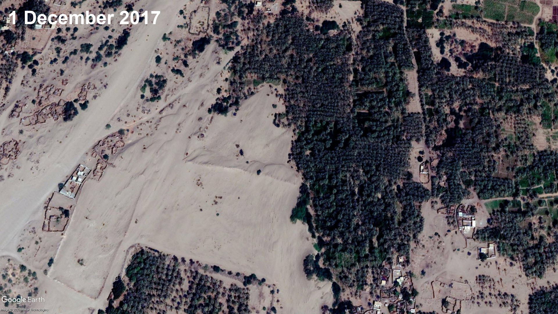
Bayt Al Faqiah
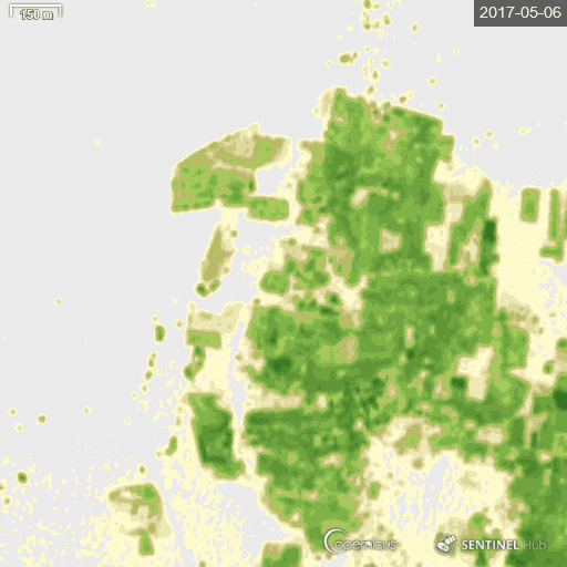
If we take the N2 30km southwards, we arrive at the date plantations that are part of the outflow from Wadi Raima and Wadi Zabid. This area hosts dozens of plantations, covering roughly 25km2 of land with date palms. This area has also faced serious problems, with a large part of the date farms at the coastal side disappearing over the course of three years.
We made a timelapse with Sentinel-2 for this area in the period May 2017-2020 to show the serious loss of date palms at this location, confirming reports in the media. The optical satellite imagery clearly shows how complete date plantations lose vegetation color over time. We used both Sentinel-2 with NDVI and the Near Infrared False Colour to look at vegetation loss here.
NDIV Timelapse showing loss of vegetation cover in the area of Al Jah Al Asfal and neighbouring towns
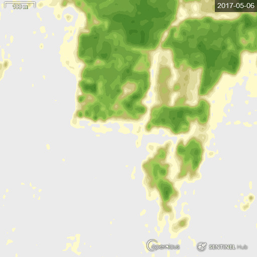
The timelapse indicates that most of the vegetation loss is in the area near the sea, so now we will use the Sentinel-2 with False Colour Index to zoom on that area and look at change in vegetation for the period:
Timelapse of date plantations with False Colour Index
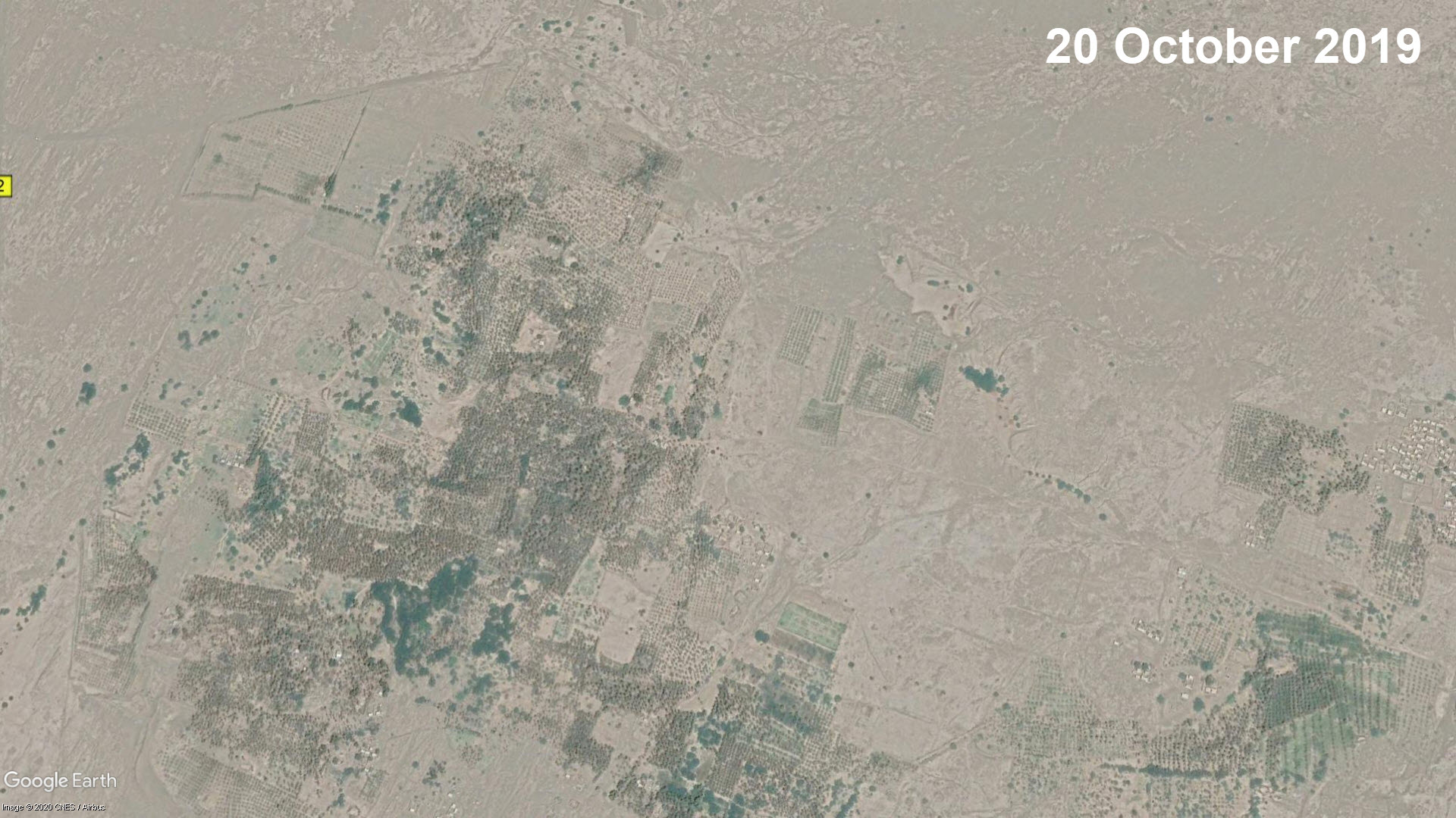
A similar, more clear image using the near-infrared (vegetation) band of the loss of date plantations can also be made with Planet Labs imagery, which has a 3-meter resolution. In the slide below the difference that occurs in the period between May 2017 and May 2020 is quite clear.
(Source: Planet Labs)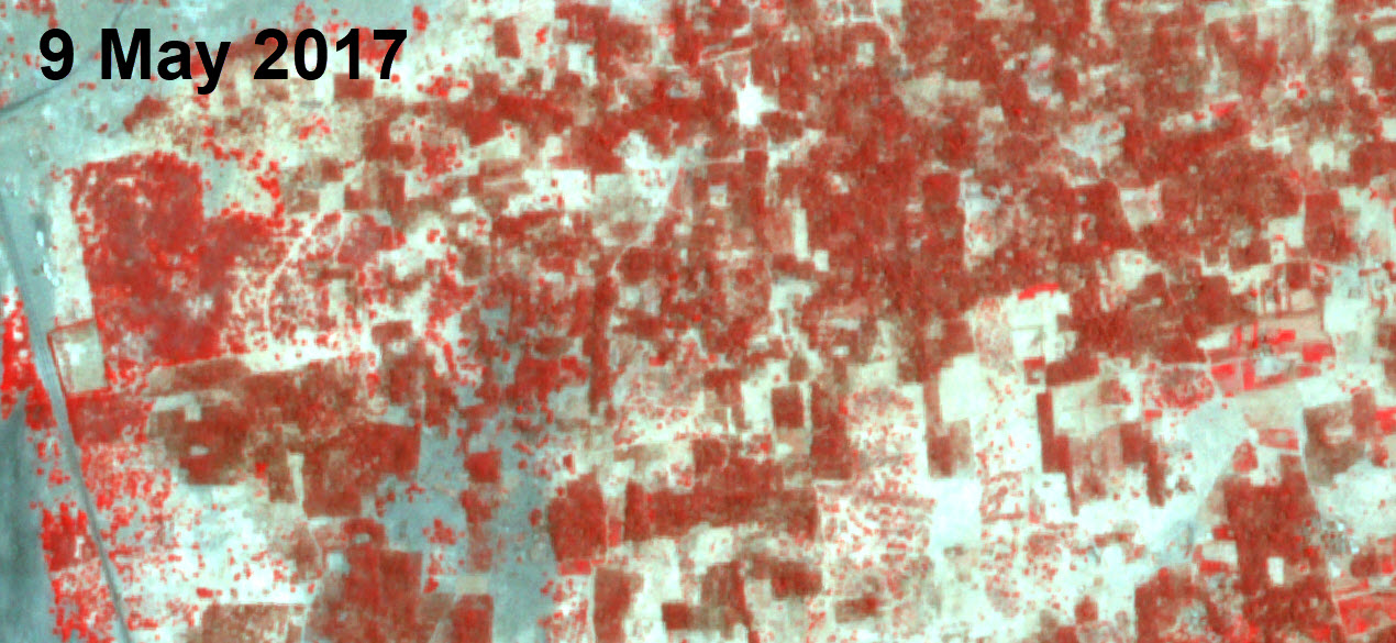
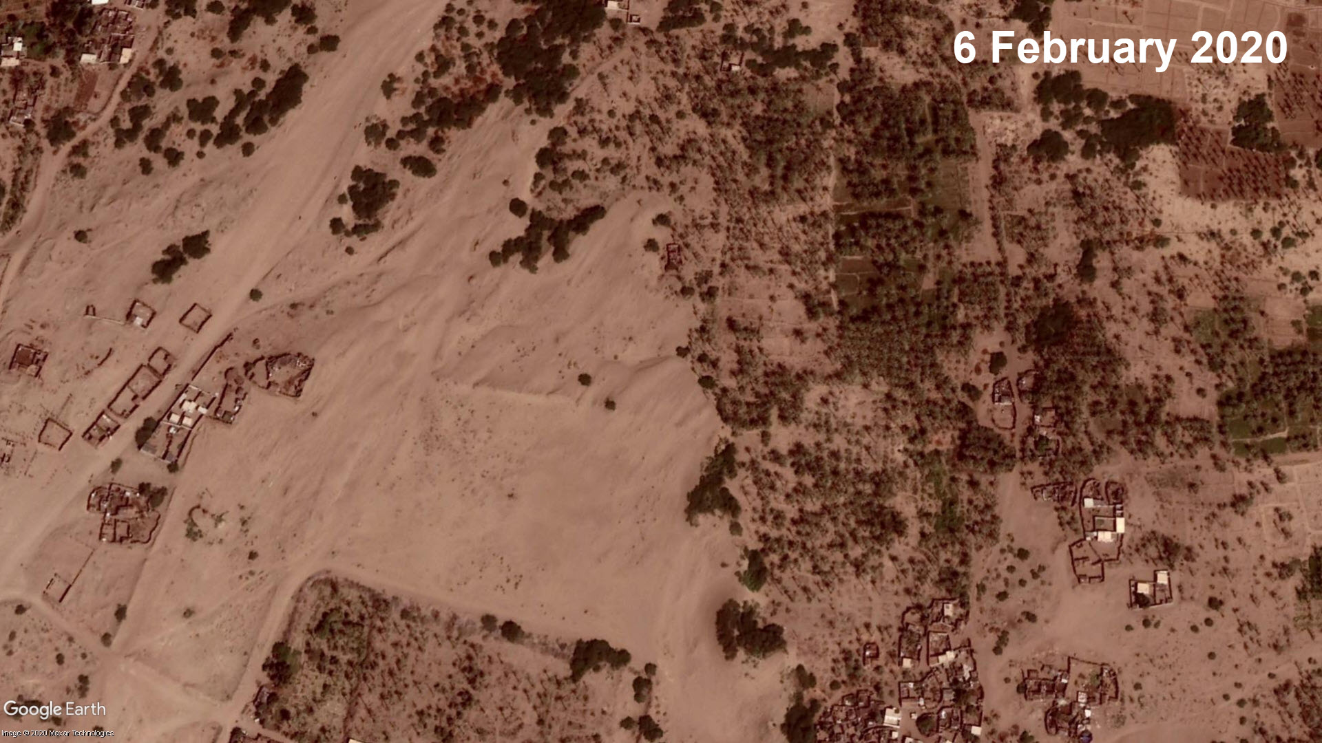
The litmus test is using Google Earth high-resolution imagery, though the latest imagery comes from 2019. At the specific locations where we have seen the loss of vegetation, Google Earth imagery seems to indicate that the date palms are still there, yet there is lost leaf cover, which likely indicates a lack of water, or other natural causes such as insects and diseases.
(Source: Google Earth)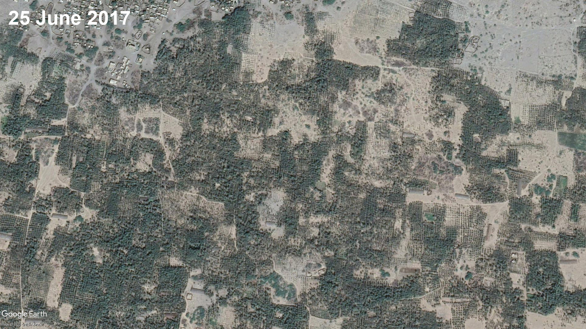
At Tuhayat
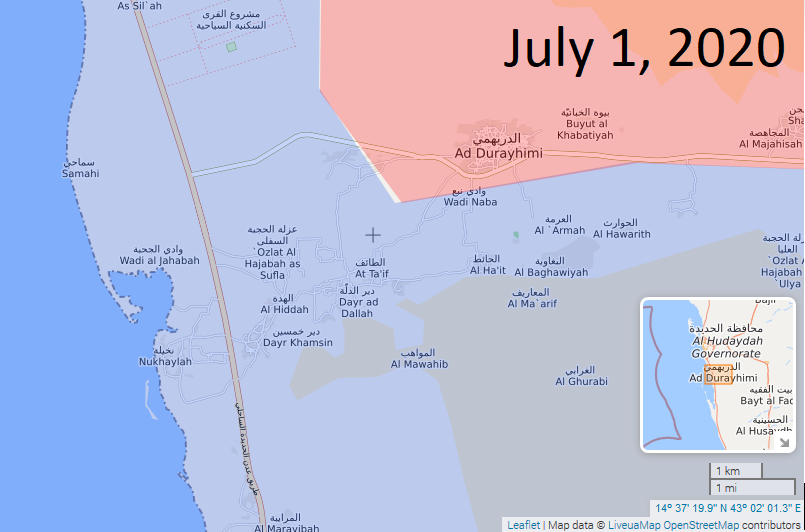
The last area in our research covers the many date plantations in the area south-west of Wadi Zabid, an agriculture rich area with fertile soil, where the date plantations are located near the coast. There is ample information available on the agricultural practices in this area, which helps us understand how the war has impacted agriculture and food security. A 2017 research development project carried out by Nuffic and partners, makes an alarming read as their survey indicates a drop in food production, malnutrition, loss of access to water sources due to higher fuel prices, damaged infrastructure, and high fuel prices, just to name a few issues. Currently the areas up towards the mountains are controlled by the Houthis (in pink), with the frontlines being at the town of At Tayahta, according to LiveUAMap’s recent information.
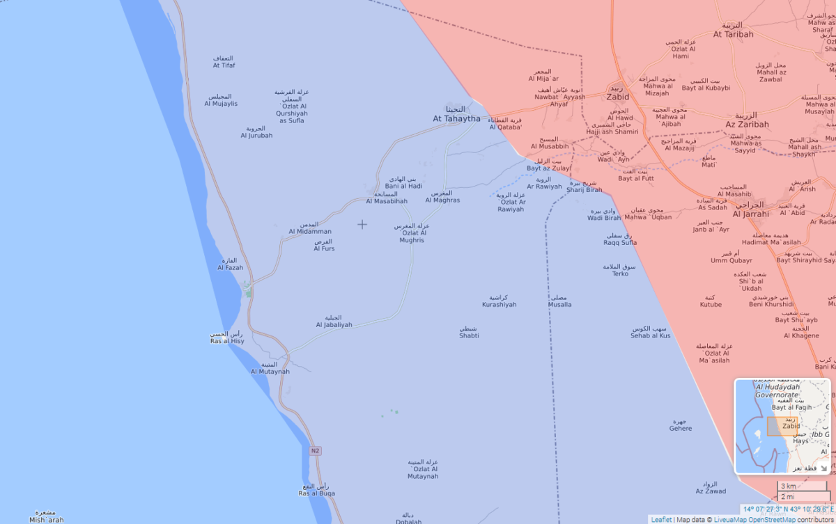
Snapshot of LiveUAMap’s site showing At Tuhayta frontlines, July 2020
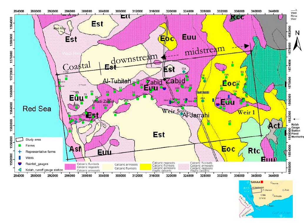
This area contains large date plantations and news reports on LiveUAmap indicate ongoing clashes between Houthis and the Saudi-backed Yemeni forces. The area was also the focus of a 2019 research paper by the Dutch University of Wageningen en Sanaa University on irrigation water in the Wadi Zabid plains, which provides additional data on the local conditions, as can be seen in the map below:
This area is prone to frequent floods after heavy rainfall, as mentioned in earlier quotes reports by FEWS, and footage can be found on social media of these floods, for example a video on Facebook from 2017 in the area of Wadi Zabid.
On the more coastal areas where the date plantations are located, droughts and lack of water from abandoned and damaged irrigation systems contributed to a decline in date palm harvests. In Al-Suwaiq, a district in Tuhayat with many date plantations, a local farmer talking to Holmakdar reporter indicated that “they left the palm trees to face their fate with drought, after no solutions or any governmental support for their irrigation could be obtained, stressing that the drought invades more palm trees every day’
In 2019, researchers also noted that as per the plantation at Al-Mujaylis, roughly 8 kilometers north of this area, there was rapid spread of other types of vegetation, such as the Prosopis juliflora. This is a small tree with deep roots that take in considerable amounts of water, affecting nearby vegetation. Such trees have sprung up in this area, resulting in date trees drying out. This study is also helpful when it comes to understanding what challenges date plantations are facing, including desertification and sand dune movement, falling groundwater levels, and the fact that due to lack of fuel, farmers cannot just pump up the water for irrigation.
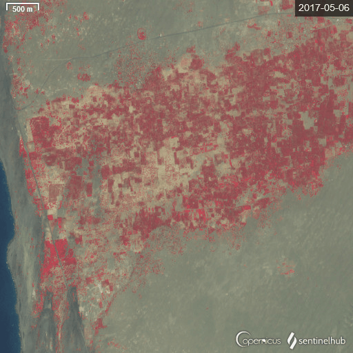
We can observe changes over time — at this location in As Suwayq, for example, which is part of the Al Tuhayit governorate. A timelapse using Sentinel-2 NDVI shows how the date palms are disappearing in three year’ time. The area was also mentioned in the 2018 Al Jazeera article, where a farmer stated that, “dates are thrown [out] because we can not market them and store them, while thousands of Yemenis are starving,”
Below is a Sentinel-2 image made with Sentinel Hub Playground Browser, using the Agricultural Index over key towns. Most of the date plantations are located in the green area between Al Fazah in the south-west and the town of At Tuhayta, which is in the north east.
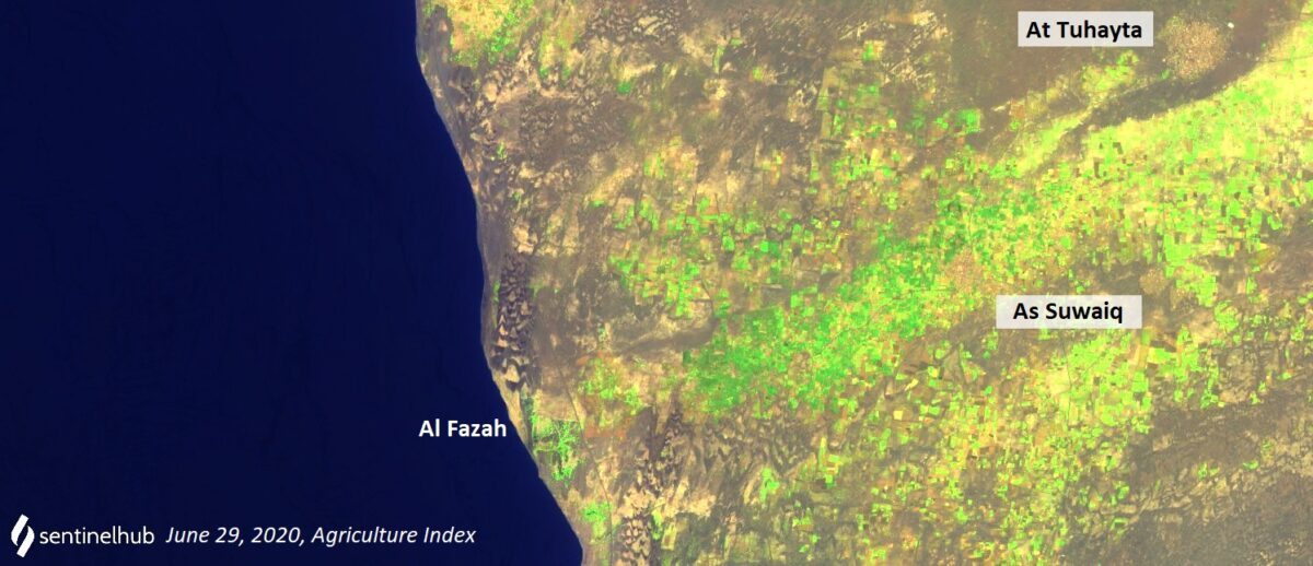
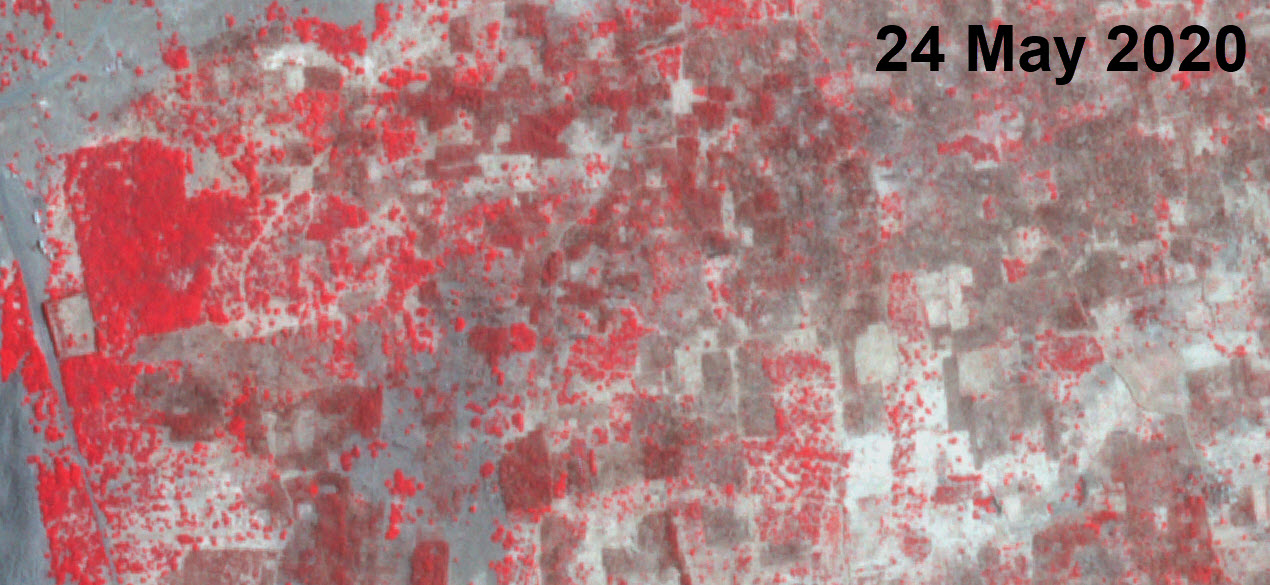
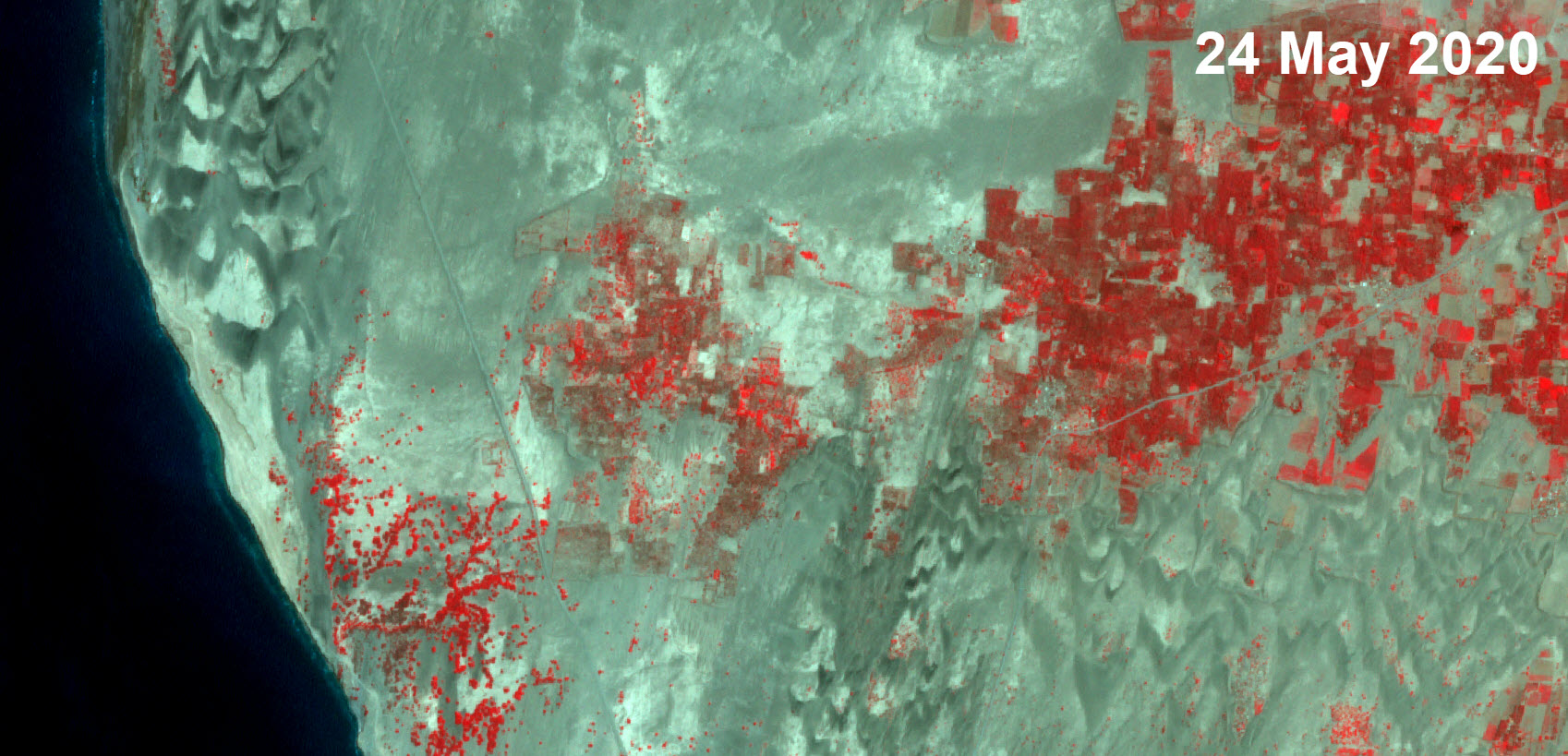
The largest visual change can be seen at plantations near to the coast, east of the town of Al Fazah. We acquired Planet Labs imagery of the location and processed it to show vegetation with near-infrared bands. You can use the slider to see vegetation loss over the course of the last three years, with imagery dating to the period from May 2017 to May 2020.
(Source: Planet Labs)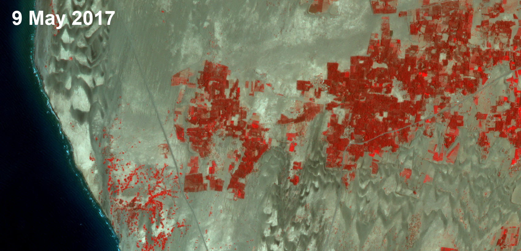
We used two timelapse here with Sentinel-2, in order to show the disappearance of trees with the Normalized Difference Vegetation Index.
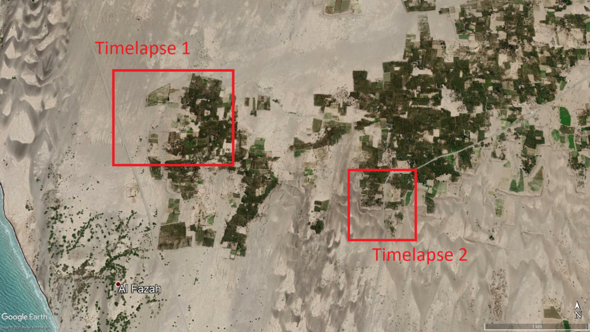
Date Plantations between Al Fazah and Al Suwaiq
Location 1, north east of Al Fazah
Timelapse with Sentinel-2 L1C NDVI
Location 2, south west of As Suwaiq
Timelapse with Sentinel-2 L1C with NDVI
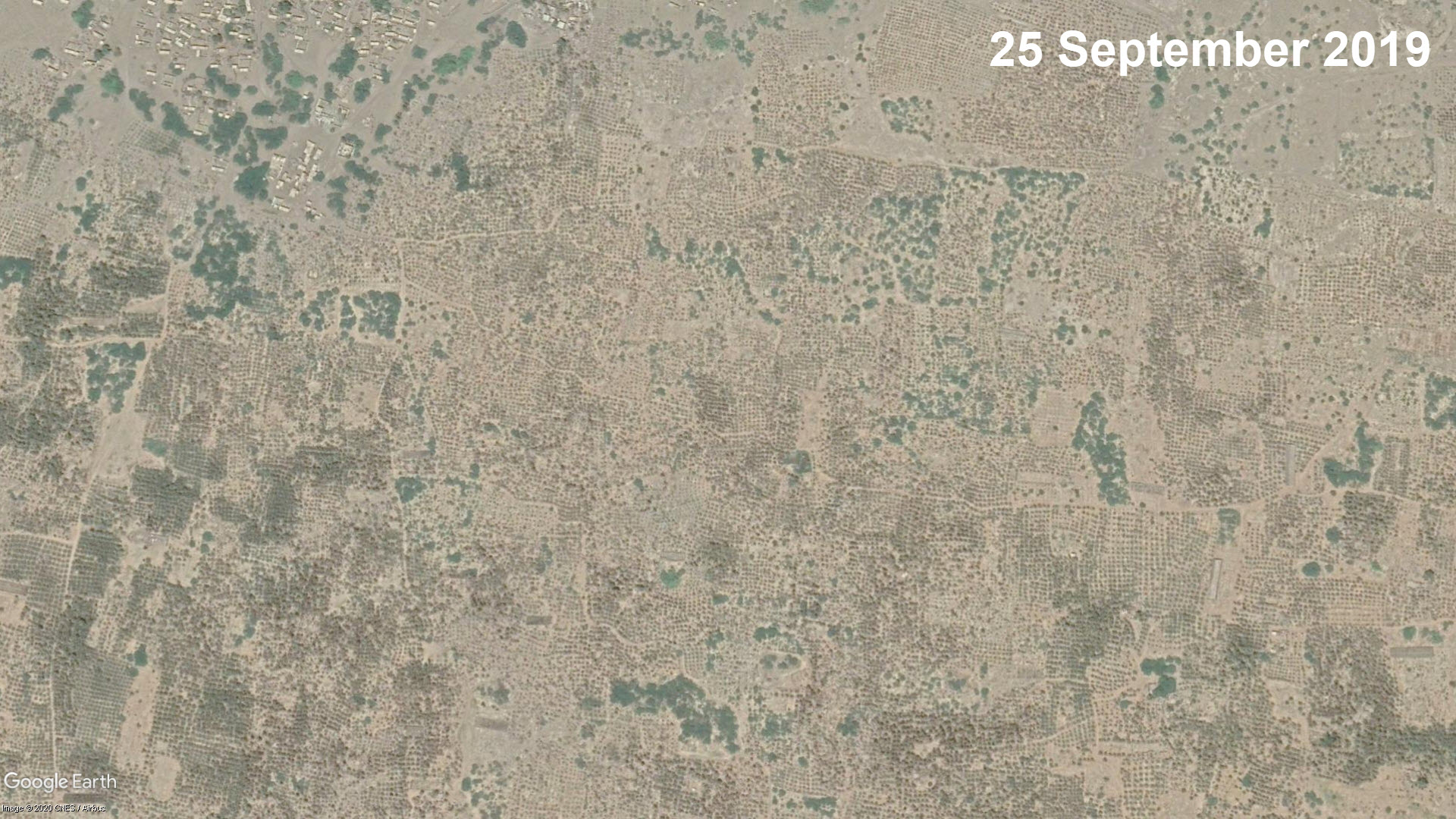
Finally, we can use high resolution imagery from Google Earth Pro from 2017 and 2020 to show the change and loss in vegetation at these date plantations. At some locations, all of the trees are gone, while the trees in other areas are still there, yet a loss of leaf cover is visible, indicating trees being affected by lack of water. The slider below shows the same areas as the timelapse from Image 1 and 2 in the overview map:
Location 1
(Source: Google Earth)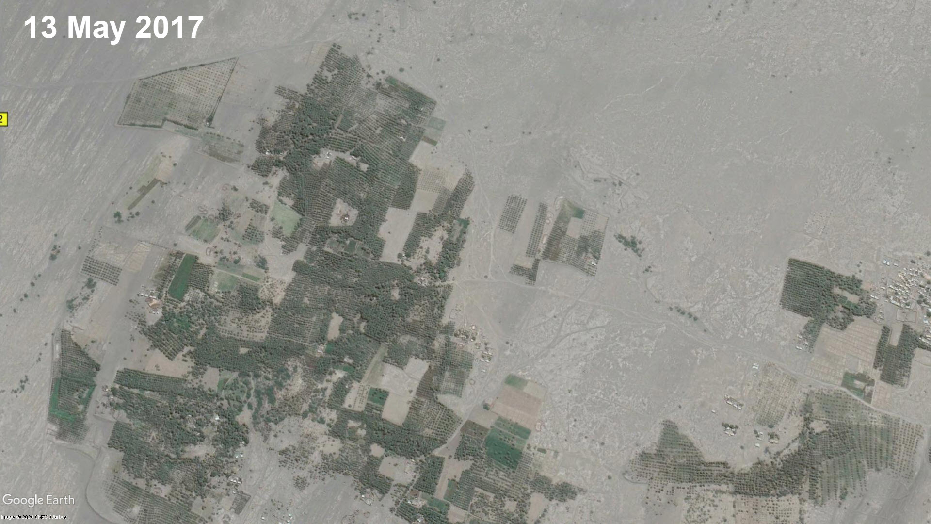
Location 2
(Source: Google Earth)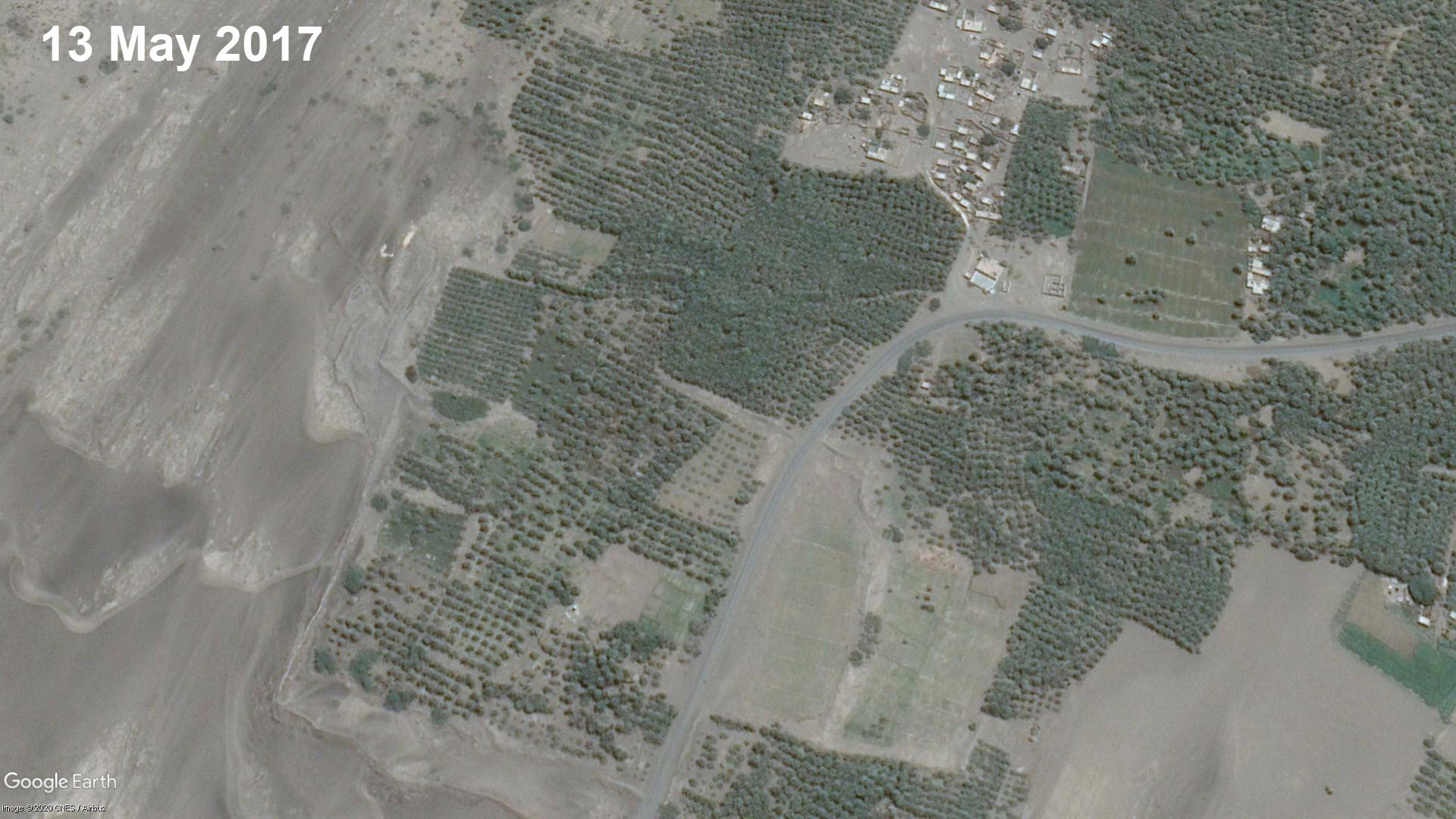
Conclusion
The visualization of environmental data through open source means helps build insight on conflict dynamics. The aim of this article was first to provide information about the ever growing amount of databases, datasets, analysism, and tools on Yemen available for researchers, concerned amateurs, and journalists specializing in agriculture and food security.
Second, we looked at one specific element, namely date palm plantations — and looked at how they were affected by the conflict. We found a wealth of tools, some more complex and requiring specialist views to assess the data, others more accessible to the average reader.
During this journey, we also learned how important the issue of natural resource management is; this includes dependency on water infrastructure, fuel prices, access to pest control, and how the reverberating effects of armed violence impact food security both directly and indirectly. At the same time, we need to also be aware of wider climate change impacts, e.g. desertification, salinization of groundwater sources, and local dynamics such water use for unsustainable qat production. All of these factors have consequences on vegetation, and it can be difficult to determine precise cause and effect in such conflicts.
The case study on the date trees was born out of the claim that a million date trees have disappeared, and with them, potential food sources, export revenues, and employment opportunities. Though satellite imagery clearly indicates severe loss of tree cover and often complete disappearance of date trees at various areas in the Tihama plains, we have not been able to verify the number of one million. However, a change is clearly visible in the areas we investigated. Using reports from international organisations, academics and humanitarian organisations, we learned that the causes of the loss of vegetation are multi-facetted: armed conflict displaced farmers that could not maintain the plantations, while the fighting damaged water infrastructure. Rising fuel prices hampered pumping up water needed for irrigation. At the same time, climate-crisis induced rise of temperatures contributed to further desertification, as did locusta and diseases, and the overal situation is worsened by the conflict-impacts. This all resulted in the disappearance of date trees on the Tihama Plains, and with it, a decrease in local food production.
The wider impact of the armed conflict in Yemen on its agriculture and natural resources which are indispensable to the survival of the population goes to show the importance of proper identification and monitoring mechanisms. This can be an accountability tool in case of deliberate targeting of environmental infrastructure — and the data can help improve humanitarian response and reconstruction efforts focussed on damage to the environment and communities depending on it.
This article could not have been made without the help and data from the following people and groups: Mwatana for Human Rights, Klement Anders, Noor Nahas, Aurora Intel @AutoraIntel, Planet Labs, Natalia Antonova.