Suez Canal: Satellite Clues on a Stricken Cargo Ship
On 23 March, facing strong winds and a sandstorm, the container ship MV Ever Given lost control, ran aground and is currently blocking the Suez Canal. The race is on to unblock the canal — whose obstruction reportedly holds up US $9.6 billion per day. Given the canal’s immense strategic importance, the ship’s predicament has attracted the attention of the world’s media.
It’s hard to miss. The Ever Given, at 400 metres long, is one of the largest container ships in the world.
It is therefore reasonable to assume that it will be easily identifiable with a simple search of satellite imagery. As such, the vessel provides an opportunity to demonstrate how open-source information and satellite imagery can help paint a detailed picture of a developing news story.
The Sentinel Hub playground tool provides free satellite imagery and can be used to obtain recent images of the area. Most parts of the world are imaged twice per week, though the imagery is lower resolution than what can be purchased from commercial satellite services. Even without knowing the coordinates for the Ever Given it is possible to make out the ship by simply searching for the Suez Canal in the website’s search field. The ship obstructing the canal can be seen from a bird’s eye view of three kilometres.
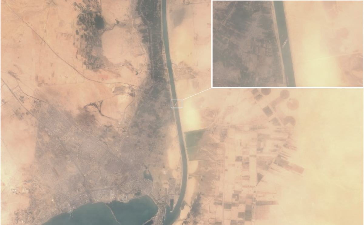
The ship can already be seen blocking the Suez Canal on various satellite images. Source: Sentinel Hub Playground
The Ever Given’s position has caused considerable problems for other vessels attempting to gain access to the Suez Canal. As Sentinel Hub updates its satellite imagery on a regular basis, we can follow the situation as it develops.
On 19 March, the portion of the Gulf of Suez — the canal’s outlet to the Red Sea — was relatively clear:
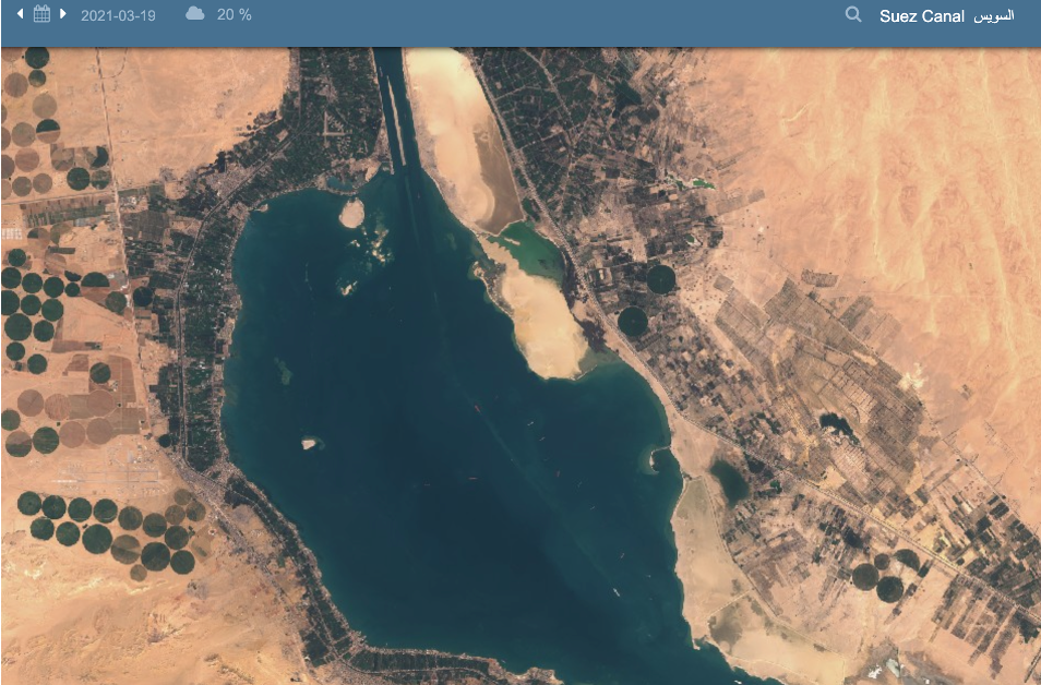
Satellite image from 19 March, only a few ships are visible. Source: Sentinel Hub Playground
But by 24 March, we can already see a large group of ships waiting to enter the canal:
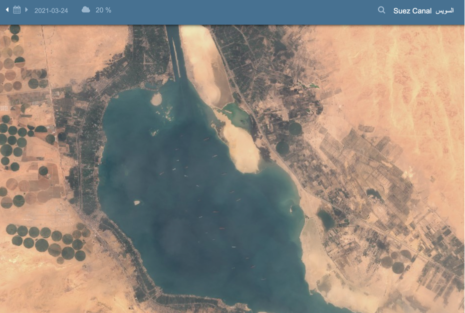
Satellite image from 24 March, a day after the Ever Given blocked the Canal. Several vessels can be seen waiting for the canal to be cleared. Source: Sentinel Hub Playground
We may wish to obtain more accurate information than a satellite image can provide. Marine Traffic is a website that provides detailed ship tracking data and monitors vessel movements. The Ever Given can be seen here, stuck and surrounded by a number of tugboats:
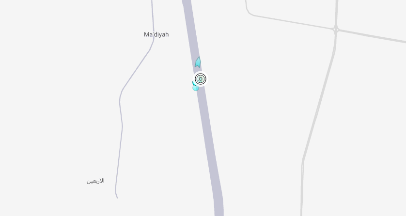
Position of the Ever Given on 26 March 2021 Source: https://www.marinetraffic.com/
We can also view the backlog of ships on both sides of the Canal in greater detail. Since the grounding of the Ever Given, Marine Traffic has shown growing numbers of ships congregating in the Gulf of Suez and the Great Bitter Lake, through which the canal runs:
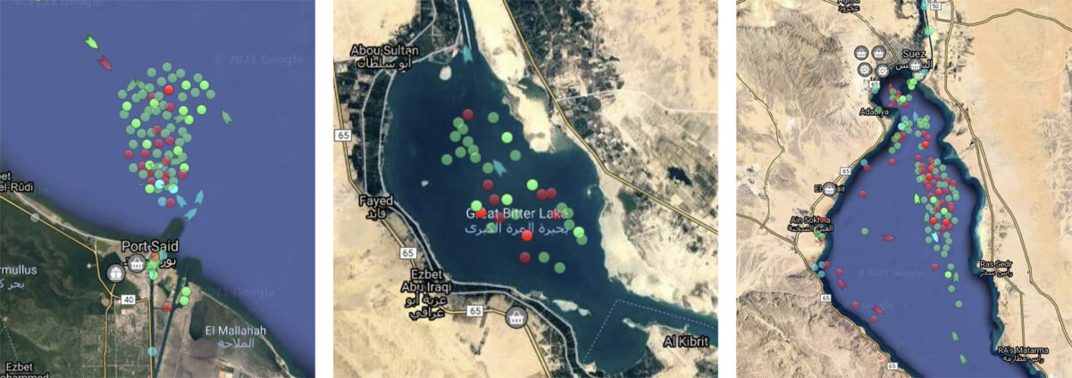
The backlog of vessels can be seen very clearly using the Marine Traffic website. These images are from (L to R): Port Saïd, the Great Bitter Lake and the Suez Gulf. Source:Marinetraffic.com
Vessel tracking
Other ships already appear to be re-routing their journeys to avoid the congestion caused by the blockage. Here, the container ship HMM Rotterdam can be seen diverting its journey at the Strait of Gibraltar:
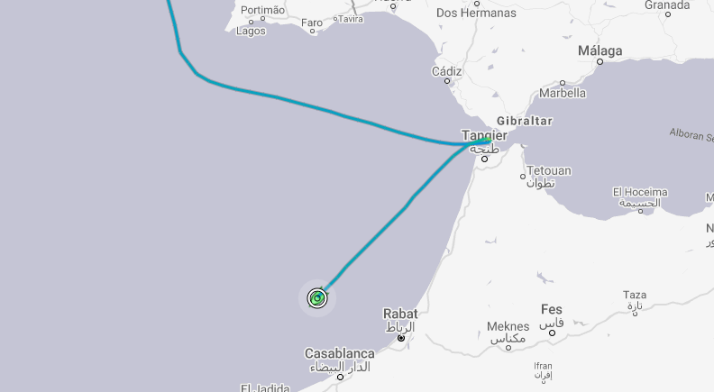
Route of HMM Rotterdam, taken on 26 March 2021. Source: https://www.marinetraffic.com/
This route can be observed on Marine Traffic by simply clicking on the ship and selecting the “Past Track” option:
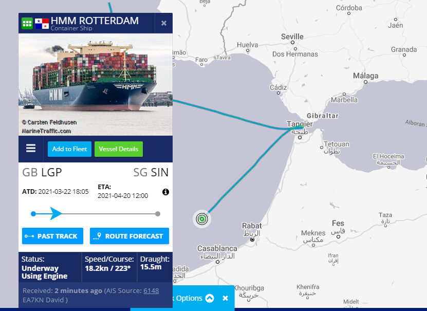
Route of HMM Rotterdam, with additional details about the ship. The ship’s route can be traced by selecting the Past Track option. Source: https://www.marinetraffic.com/
This diversion has been noted by Marine Traffic’s own Twitter account, a useful resource for visual updates about the Suez Canal incident:
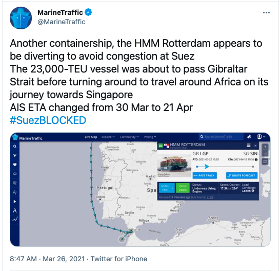
Source: https://twitter.com/MarineTraffic/status/1375353647937290245
Canal depth
Open source information can also shed light on how the Ever Given became stuck — and why freeing it could be no mean feat.
Bathymetry data from https://www.myshiptracking.com/ shows that the current dredged channel is 25m deep, but only runs along the west side of the canal. Importantly, it also shows relatively broad, sloping walls, especially along the east side of the canal. The solid blue area represents very shallow water, less than 0.5 meters deep.
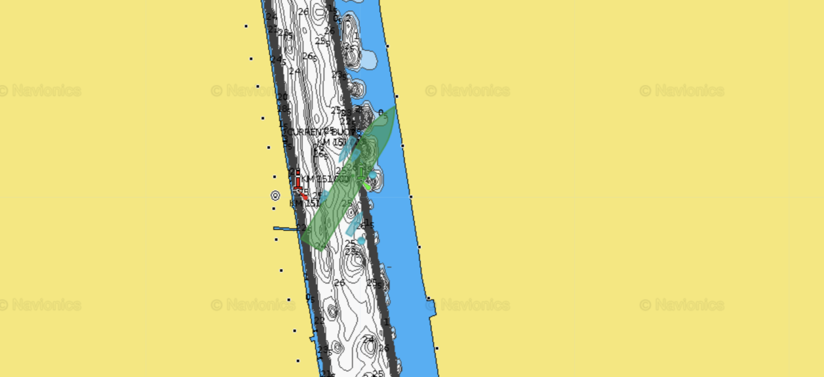
Bathymetric map of the Suez Canal at KM 151, with position of the Ever Given superimposed. Source: https://www.myshiptracking.com/
Cross-referencing these depths with imagery provided by Airbus can be helpful for visualising where the water under the Ever Given might be shallow:
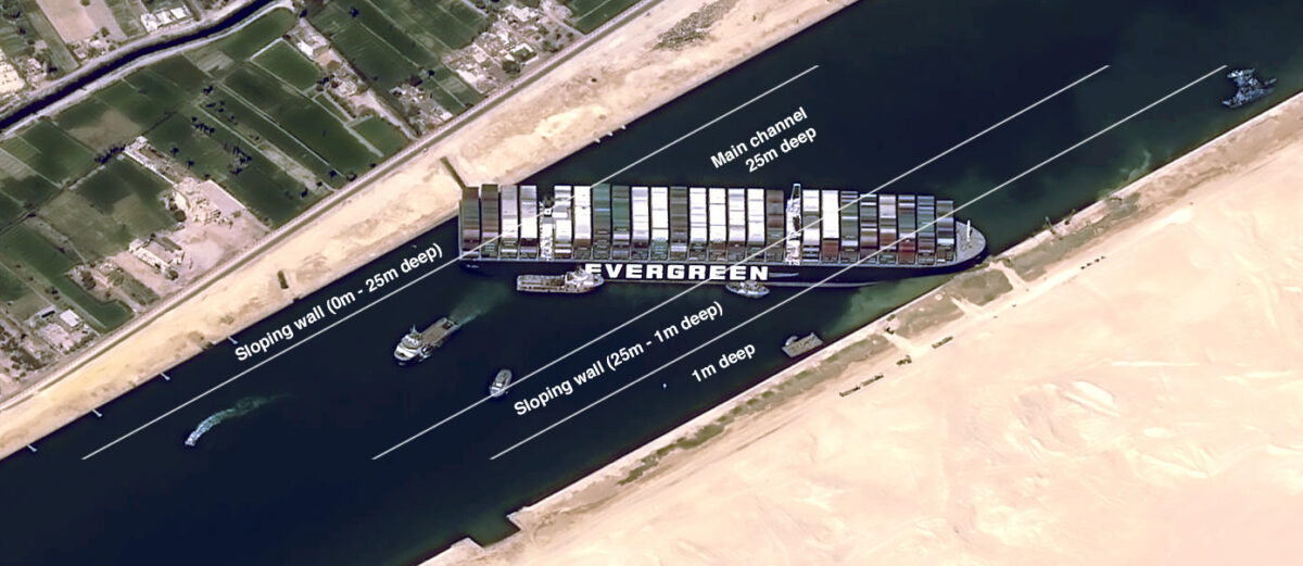
Approximate dredged depths of the Suez Canal, overlaid on an Airbus satellite image. Data is taken from the nautical chart referenced above. Credit: Airbus / Logan Williams / Bellingcat
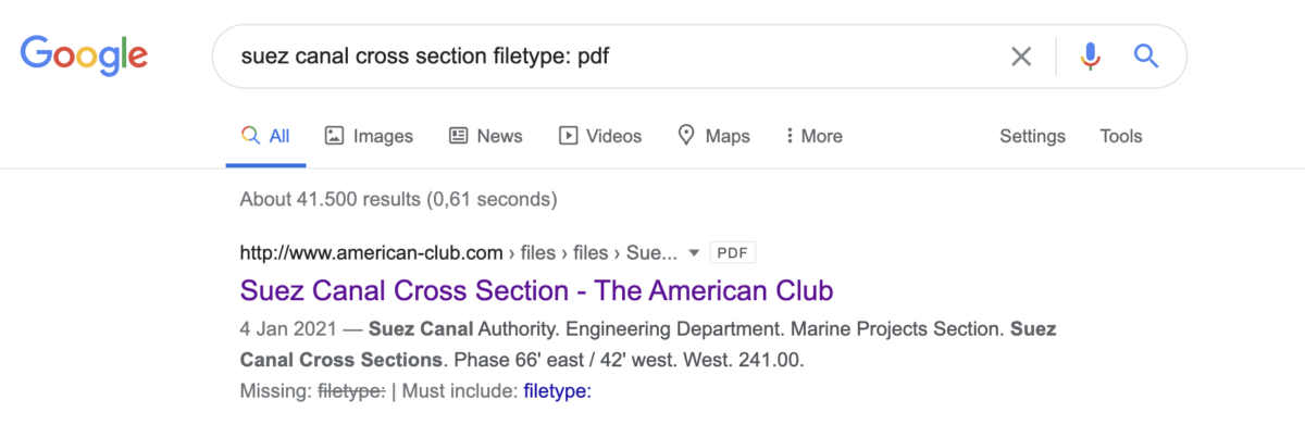
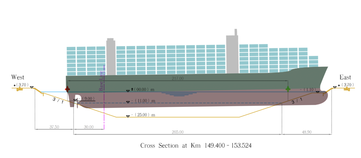
We can attempt to validate this depth information by comparing another source. A Google search for “suez canal cross section filetype:pdf” finds an engineering document with cross sectional diagrams for multiple locations along the canal, hosted by a maritime protection and indemnity insurance company. While the exact provenance of these diagrams is unclear, they claim to be produced by the Suez Canal Authority and are dated from 2015. They also reference the 66’ draft improvements, completed in 2010. This search demonstrates the use of a filetype query, which can be very useful for finding publicly accessible documents:
Vessel Finder, another ship tracking website, provides the precise coordinates of the Ever Given, which is located at KM 151 along the canal:
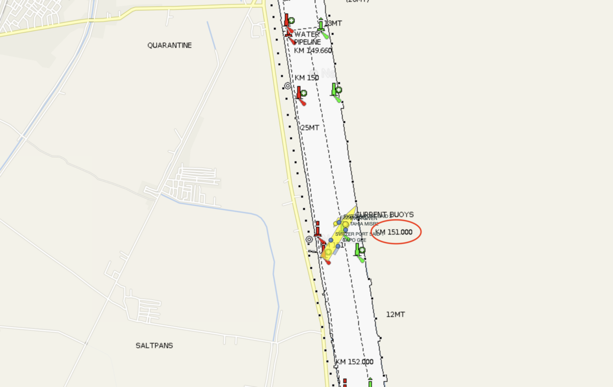
Location of the Ever Given. Source: Vessel Finder
This corresponds to this cross-sectional diagram from the PDF document, which shows how the channel profile is designed:
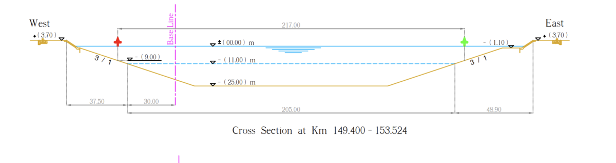
A cross section of the Suez Canal from Km 149.4 to Km 153.524. Credit: Suez Canal Authority, American P&I Club
This differs from bathymetry data, showing the channel in the center of the canal, wider walls, and a smaller shallow eastern shelf. However, as the Suez Canal must frequently be dredged to remove silt, some variation from the designed profile is not too alarming.
To try a second way of visualising the situation, an approximation of the ship can be simply superimposed on the canal cross section. Vessel Finder data shows that the Ever Given is positioned at 50.2º angle with respect to the side of the canal. This means that in cross section, its 400m length is foreshortened to approximately 256m.
A diagrammatic view of the Ever Given can then be scaled along the x-axis by 64 percent to represent the view in cross-section. This stretched diagram can then be scaled using the overall length and dimensions in the cross-sectional engineering illustration. Open source imagery shows the approximate angle of the vessel with respect to the surface of the water, and the approximate position of the front of the vessel with respect to the side of the canal:
An approximate diagram of the Ever Given’s position. Credit: Suez Canal Authority / Logan Williams / Bellingcat
This shows the likely scenario that, despite the effort expended in digging out the top section of the vessel’s “bulbous bow,” a significant portion of the Ever Given remains beached on the shallow sloping edges of the canal.
All of this should be understood as only an approximation of the real situation using information available from open internet sources. In any case, these resources can be helpful when trying to understand the severity of the vessel’s position.
Salvage
As the presence of several Egyptian tugboats on the MyShipTracking image indicates, efforts to rescue the Ever Given are already underway. The vessel’s owner has already called upon the services of Smith Salvage BV, part of the Dutch company Royal Boskalis Westminster. The company states on their website that they provide a full range of salvage and towage services and provide a 24/7 emergency response.
The company has an impressive track record. Their YouTube channel details how they have salvaged several large vessels, including the Russian military’s Kursk submarine that sank in the Barents Sea on 12 August 2000.
As the operation to free the Ever Given commences, the coming days and weeks will be an interesting time to monitor the operation using some of the tools and techniques described in this article.
Although OSINT resources are no substitute for sources on the ground, these techniques go to show that a deeper insight into this developing news story can be quickly obtained from free and open sources.
Written and researched by Ross Higgins, Annique Mossou and Logan Williams
Correction (3/29): Data on map of dredged depths (Airbus image, with Ever Given superimposed) adjusted.
Correction (3/26): Discrepancies between engineering cross-sections and chart bathymetry clarified. Thanks to @jsrailton for the feedback.