Anatomy of a Shelling: How Russian Rocket Artillery Struck Mykolaiv
Translations:
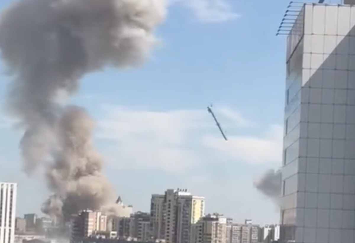
On April 4, 2022, Russian rocket artillery struck the Ukrainian city of Mykolaiv with cluster munitions. On the night of April 3, the Furshet shopping centre and nearby city hospital were attacked. Local media had published images to their Telegram channels at around midnight. At 8:03 in the morning of April 4, eyewitnesses told the Ukrainian website Prestupnosti.Net of damage to residential areas in the Zavodskyi District. Later, on the afternoon of April 4, a second attack followed in which a shopping precinct and a children’s hospital were attacked. Both were located in densely populated residential areas. According to the Mykolaiv regional prosecutor, 12 people died and 41 were injured from the attacks.
Videos of rocket launches began to appear on social media after the attacks, with the uploaders claiming that they were firing towards Mykolaiv. A close inspection of one of these videos has allowed Bellingcat to verify the location of the rocket launches likely behind the afternoon attack on the shopping precinct and children’s hospital. It is as yet unclear whether the same location and rocket launchers were implicated in the early morning attack that day.
Our geolocation suggests that the strike was launched by Russian forces from a location near the Inhulets River in the north of Russian-occupied Kherson Region; a chronolocation of the same videos indicates that one launch likely took place just minutes before the afternoon’s explosions at the shopping precinct and children’s hospital occurred.
This attack was one of dozens launched against the port city throughout the spring and summer of 2022, after Russian forces from occupied Crimea swept through Ukraine’s south and were held back by the Ukrainian army just outside Mykolaiv city. It came just days after a Russian cruise missile destroyed the regional government office on March 29, which Ukrainian officials say killed 12 people.
Mykolaiv’s Regional Governor Vitaly Kim narrowly avoided that attack on his workplace. By the time Ukraine’s army retook Kherson in November, Kim estimated that around 200,000 of Mykolaiv’s 470,000 residents remained in the city.
The Aftermath
As soon as news of the April 4 attacks broke, imagery emerged showing the scale of destruction. Locals shared videos and images on social media. These sources indicate that most casualties that day appeared to be concentrated in the commercial area where people had been working and shopping. There was also a public transit stop at this location.
The paediatric hospital shown in this surveillance footage is about 800m from another attack in Mykolaiv yesterday that killed multiple people near a shopping strip at 46.943047, 32.055330: https://t.co/iV07BMbjYY https://t.co/4hAqMu4hGO pic.twitter.com/dsJnk61MMy
— Jake Godin (@JakeGodin) April 5, 2022
Security footage from the paediatric hospital first appeared online the day after the attack on the Telegram channel of Governor Vitaly Kim, who shared it at 13:58 (local time). It was then widely amplified by the channel of the local branch of Suspilne, a Ukrainian media network. The video showed that the submunitions, which detach from the launch rocket close to impact and spray over a target area, hit the hospital at around 15:30, according to the timestamp of the CCTV camera. On April 8 Chief Doctor Oleksandr Plitkin told reporters for the TPK channel that nobody at the hospital was harmed physically, but that the hospital building did take exterior damage, of which photojournalists from NPR also published photographs.
This video, with a date and timestamp consistent with the @MSF_Ukraine report, shows an impact at the paediatric hospital.https://t.co/iz9XqOpMzK https://t.co/kO0MYUvRms pic.twitter.com/ea3ckTphGj
— Eliot Higgins (@EliotHiggins) April 5, 2022
The timing of these video clips offered clues as to when precisely the projectiles hit downtown Mykolaiv that afternoon. But where did they originate from?
The Trajectory
Statements by people who witnessed the attacks offer some clues as to the origin of the projectiles.
On April 5 Médecins Sans Frontières (MSF) Head of Mission in Ukraine Michel-Olivier Lacharité stated that “Several explosions took place in close proximity to our staff over the course of about 10 minutes.” Staff of the international medical charity were visiting the city’s oncology hospital at the time.
In a Twitter thread on the same incident, MSF Ukraine stated that their team had been about 300 metres away from the paediatric hospital and saw small holes in the ground which may have indicated the use of cluster munitions.
The team reported that the regional paediatric hospital, about 300 m away, was also hit. No large crater was visible. In the wake of the explosions, they saw numerous small holes in the ground, scattered over a large area. This could be consistent with the use of cluster bombs.
— MSF Ukraine (@MSF_Ukraine) April 5, 2022
As Bellingcat has previously reported, Ukrainian civilians across the country have documented the remnants of cluster munitions since Russia’s invasion. Cluster munitions deploy a large number of smaller submunitions over a target which then explode over a larger area, increasing the potential for casualties.
The small holes in the ground mentioned by MSF are a tell-tale sign of this weapon’s use, as are the remnants of the rockets which delivered them.
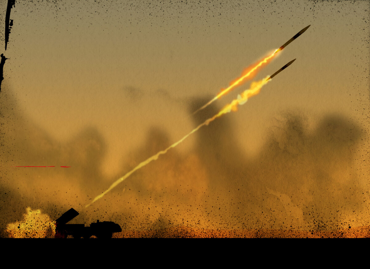
Several videos and images from Mykolaiv which appeared on local Telegram channels after the explosions included even bigger clues – such as remnants of the rocket motors, submunitions, booster and cargo sections of rockets.
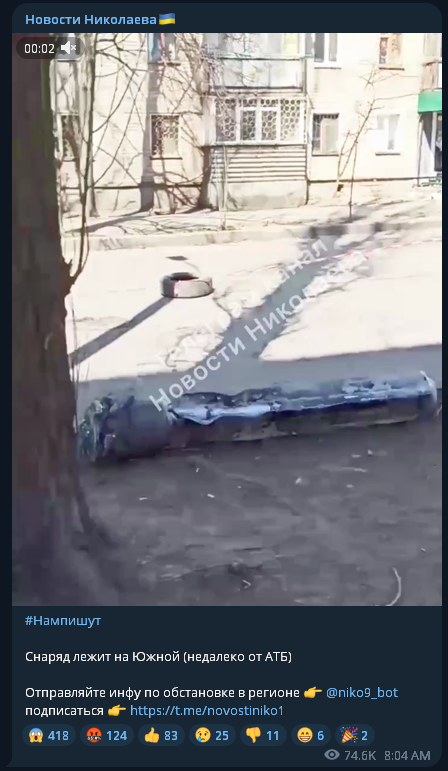
These remnants were consistent with a 300mm cluster munition rocket like that of the 9M55K type, which Bellingcat found to be one of the most commonly used in Ukraine since Russia’s invasion. These rockets are fired by 300mm launchers like the BM-30 Smerch multiple launch rocket system (MLRS).
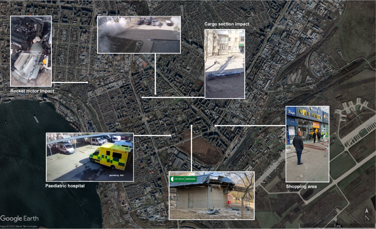
Images containing such debris which appeared online directly after the explosions were geolocated and plotted on a Google Map showing the location of the affected areas and the concentration of fire on Mykolaiv’s city centre.
These impact sites lined up along an axis from the north-west to the south-east, until the cargo pod and rocket section had come to earth.
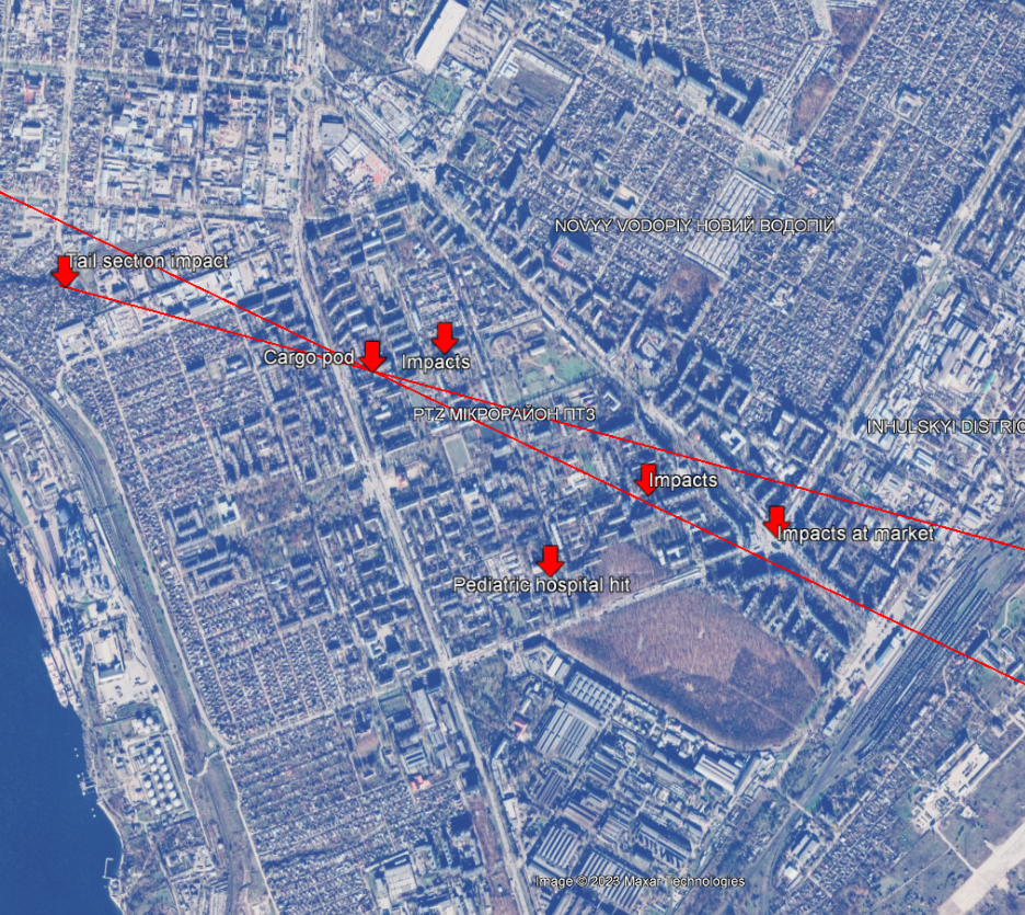
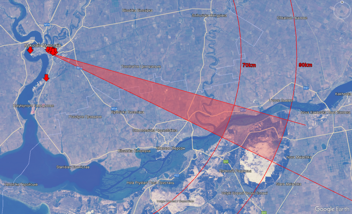
These locations could then be used to narrow down the possible trajectories of the projectiles, represented by two red lines. These lines intersected where the cargo section of the rocket was geolocated. Having identified the likely weapons system, we could then draw a circle around the city centre with a diameter of 70 and 90 kilometres which, according to the website of Russian defence exporter Rosoboronexport, are the maximum firing ranges of 300mm cluster munition rockets.
Therefore, the rockets which struck Mykolaiv that day would likely have launched from somewhere within the shaded red triangle in the map below.
Finding the Launch Site
As the area between Mykolaiv and Kherson was a highly active warzone, there may have been rocket artillery movements which were not captured by open sources. However, one launch was.
After news of the attacks surfaced on April 4, videos appeared online which purported to show multiple launch rocket systems in action between Russian-occupied Kherson and Mykolaiv.
Some videos posted to Telegram channels on April 4 showed launches from the northern suburbs of Kherson city towards Mykolaiv, but these had been taken the previous day given that they appeared online shortly after midnight but depicted the area during daylight hours. These were disregarded for the purposes of identifying the launch site for the attack later that day.
Others which appeared later in the day on the popular KhuyeviyKherson Telegram channel were quickly deleted. These had been archived by Bellingcat before their deletion.
However, some of the latter were reposted by third parties and so remained online. For example, at 17:33 on April 4, the pro-Russian Vvoenkor Telegram channel posted two videos published earlier with the words “Powerful Russian MLRS ‘Smerch’ or ‘Uragan’ hit the enemy from Kherson in the direction of Mykolaiv”.
One of the videos showed two buildings downhill from the camera, with a solar panel in the foreground. The cameraperson appeared to be standing on a public road in the village, something we later determined through satellite imagery. The rocket launcher was visible in the background, on top of the hill on the other side of the valley from the camera. Its silhouette resembles a common Soviet-produced MLRS (multiple launch rocket system) such as the BM-30 Smerch.
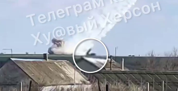
Given that several channels which reposted this video stated that the launcher was firing towards Mykolaiv, this offered a clue as to the direction of the camera. Also taking into account the position of the sun, this video was deemed to be roughly southward facing.
If the video could be geolocated to an area within our aforementioned search zone, based upon the range of 300mm cluster munitions rockets, it would be a candidate for the launch which struck Mykolaiv that afternoon.
However, as it was also possible that this video depicted a different launch, or that the suspected trajectories were incorrect, we also searched well outside the target area denoted by the red cone.
At the far end of the 70km search area we had narrowed down, we found a match by trawling mapping services and matching the positions of features seen in the video. The patterns of discolouration on the roofs, chimney positions, solar panels, and a garden in the foreground allowed us to be sure we had the correct match. We now knew that the video was filmed within our suspected launch area — the red cone.
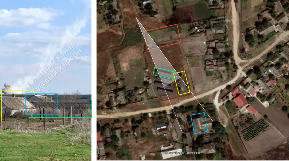
We were then able to follow the line of sight from the camera, to an elevated position on the other side of the Inhulets River.
When looking at historical satellite imagery from the ArcGIS archive, we saw a distinctive mark alongside a road connecting the town of Inhulets with the E58 highway.
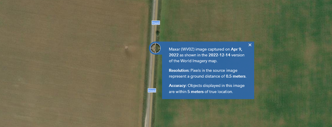
The ArcGIS website allows users to see the collection date for any satellite imagery it provides in any location. It revealed that the imagery including this mark was collected on April 9 – five days after the videos were posted. The mark was not visible in earlier high-resolution imagery from before the war.
This mark is consistent with those seen on terrain elsewhere in Ukraine, in areas where rocket artillery has been in use.
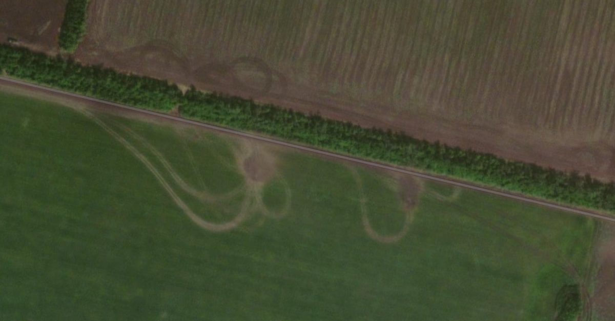
It was characterised by its point where the blast from the rockets was most concentrated and then spread out rearward.
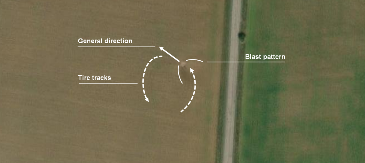
We also noticed a set of tyre tracks leading north from the road which stopped at the probable blast mark. These tracks then performed a u-turn and headed back in the direction they came from.
Building a Sundial
Using the BlenderGIS plugin in Blender 3D, we were able to reconstruct the scene. Because the ESRI imagery was so recent, it could be used to reliably depict patterns of grass, dirt, and crops in the fields that the launcher was firing from.
However, elevation data from other public sources (such as OpenTopology) is lower fidelity. For this reason, as well as the inability to perfectly recreate camera lenses, 100% accurate recreations of the landscape were not possible. Nevertheless, reasonable visualisations could be created from the satellite images, using the reference imagery for height cues only.
These height clues enabled us to attempt a faithful recreation of the scene based on what could be seen in the video.
When attempting to recreate the scene, we noticed a shadow cast from the chimney on the far building. We attempted to use it to roughly chronolocate the launch, in other words, determining what time of the day it happened.
An accurate chronolocation was not possible because the angle of the roof cannot be known without physically measuring it at the site. However, a rough estimate could be reached to see if the launch could have coincided with the 15:30 timestamp on the children’s hospital security camera in Mykolaiv that afternoon.
Using SunCalc, we took the sun’s altitude (37 degrees) and azimuth (230 degrees) at that location for April 4, 2022, at 15:25 and plugged it into Blender’s sun disk function. This is an artificial atmosphere which Blender can generate based on chosen inputs, allowing users to visualise a setting of their choice.
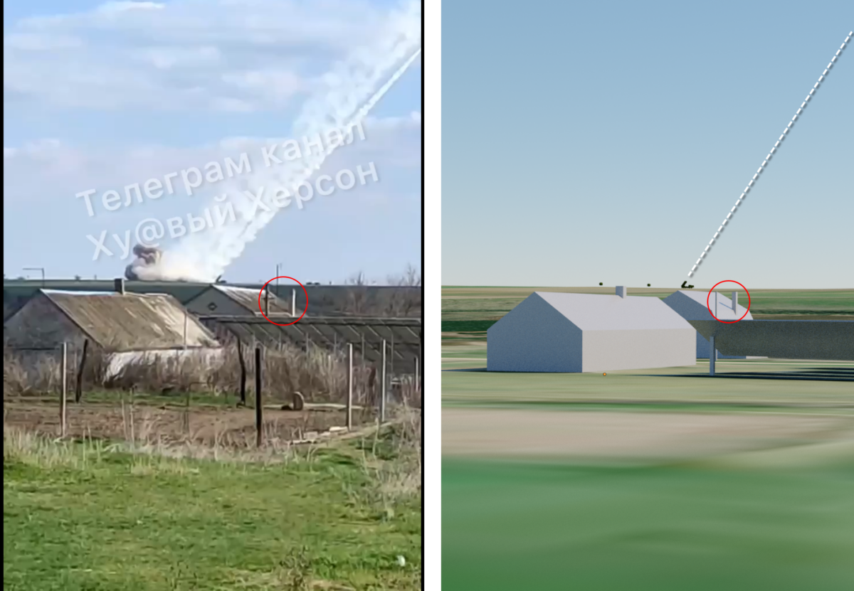
The result was a near identical shadow cast onto the roof of the background building. Visual inspection of the shadow cast onto the map on SunCalc also revealed a highly similar angle, and confirmed with certainty that the launch took place in mid-afternoon, plausibly at around the time of the impacts in Mykolaiv.
At the time these videos were filmed, this location not far from the Inhulets River was under the operational control of the Russian military according to Liveuamap, a regularly updated interactive map of the frontlines in Ukraine and other conflict zones.
This makes it highly unlikely that Ukrainian forces were responsible for the launch. The Russian army would not be ousted from this area until the start of a counteroffensive to retake the Kherson Region in the start of September 2022.
On this basis, Bellingcat continues to attempt identification of Russian military units equipped with rocket artillery which may have been active around this launch site at the time of the attacks.
Jake Godin (Scripps News) contributed to this investigation
Editor’s note — the final image in the earlier version of this investigation highlighted the incorrect chimney in a red circle. The error has now been corrected.