The Yemen Project: HAJ 10003 – Aahim Triangle, Bani Hassan, Hajjah
Translations:
Incident ID: HAJ10003
Location: Muthalith Aahim (Aahim Triangle), Bani Hassan, Hajjah Governorate, Yemen
Coordinates: 16.325139, 43.089533
Incident Grading: Likely
Date: 2015-07-04
Time (AST): 1730–1900 UTC (MSF states 20:30 AST. HRW states “about 22:00” AST)
KEY FINDINGS
– On the evening of 2015-07-04, an explosion occurred near a restaurant in Muthalith Ahim injuring and killing multiple civilians.
– Human Rights Watch (HRW) reported that at least 65 people were killed and 105 wounded. Médecins Sans Frontières (MSF) reported on 2015-07-07 that there had been 20 deaths in a market in Harad district, where Muthalith Ahim is located, and that their team treated over 67 injured people.
– The HRW report titled: “What Military Target Was my Brother’s House: Unlawful Coalition Airstrikes in Yemen” provides a comprehensive narrative including eyewitness accounts of a number of alleged airstrikes that took place on the Muthalith Aahim (‘Aahim Triangle) and in the nearby village of Haradh. The attack we analyse in this report is the one referred to in the section of the HRW report titled “Muthalith Ahim”
– Open source information gathered and verified by investigators indicates that on the night of 2015-07-04 what was likely an aerial bomb detonated in Muthalith Aahim. This explosion killed and wounded a large number of people who appear to be civilians. The location at which this explosion took place was in the center of Muthalith Aahim, near restaurants, a hospital and other market stalls. There was also what appeared to be a water-truck several meters away from the point of detonation.
– The incident occurred during the month of Ramadan in the evening. It is expected that a large number of people, locals and travellers, would have congregated in the restaurants to continue eating into the night, having broken their fast after the dusk prayers at the nearby mosque.
– There appears to be some confusion over the number of munitions dropped due to other airstrikes occurring within that general area at the same time. Open sources only identify one crater and as such our analysis indicates only one munition was dropped on Muthalith Aahim which caused mass civilian casualties.
DISCOVERY
The sources used in this report were found by searching for variations of “Muthalith Aahim” and “Bani Hassan” in both English and Arabic across different search engines and social media platforms. Time limitations and advanced searches were used to search specific date ranges around the time of this incident. Searches on YouTube were conducted using the same keywords in both English and Arabic, and videos were filtered by date to aid identification.
The following sources were discovered:
NGO reports:
A report by MSF
A Facebook post by MSF
A report by HRW
A report from the Legal Center for Rights and Development (LCRD) [Investigator 0306 note: the domain appears to have expired since the report was found. It might be worth contacting the organisation that produced it: The Legal Centre for Rights and Development, or check the relevant Hunchly files.]
YouTube videos:
Preliminary scenes from the second Saudi-American massacre in the popular market [translated from Arabic] posted by “The media front to confront the Saudi aggression on Yemen” [translated from Arabic] on 2015-07-05 at 22:04 UTC. (Referred to as the “aftermath video”)
Saudi-American Aggression targeting the Market of the triangle Aham in Hajjah province [translated from Arabic] posted by “Ansar Allah Media Center” [translated from Arabic] on 2015-10-29 at 15:19:17 UTC
The first anniversary of the massacre of the Triangle [translated from Arabic] posted by “Khaled Massaad” [translated from Arabic] on 2016-06-21 at 1323 UTC
A protest in the Triangle of Aham to provoke the report of Khaled Massad [translated from Arabic] posted by “Khaled Massaad” [translated from Arabic] on 2016-06-23 at 1045 UTC
شهداء وجرحى بغارات للعدوان السعودي على مثلث عاهم بحجة posted by YemenTodayChannel on 2015-07-25 aty 1655 UTC
2015 05 24 Targeting the US-Saudi aggression against the Triangle of the Harad Directorate [translated from Arabic] by “The media front to confront the Saudi aggression on Yemen” [translated from Arabic] posted on 2015-05-24 at 1841 UTC
Shaharah news report: 30 fatalities
Ansarollah.com report: 30 fatalities
Al Methaq report: 30 fatalities
A blogpost collating a number of reports and videos by the Yemen War Crimes Blogspot
WHERE?
The incident took place in the Muthalith Aahim (‘Aahim Triangle) near the town of Haradh in the Hajjah Governorate. The “triangle” is formed at the point where the N2 Road (also marked as 5 Road and 45 Road) with a roughly North-South direction from the Saudi/Yemeni border, forks into two sections after it passes through the town of Harad, one southwards toward the provincial capital Abs, the other to a south-eastern direction towards Amran.
There are a number of sources (HRW report, MSF article, aftermath video) which identify the location of the incident as being this particular junction on the road. We were also able to locate the position of the Sanaa restaurant, which is mentioned in a number of reports: Google Maps marks it as being at 16.325183, 43.089926.
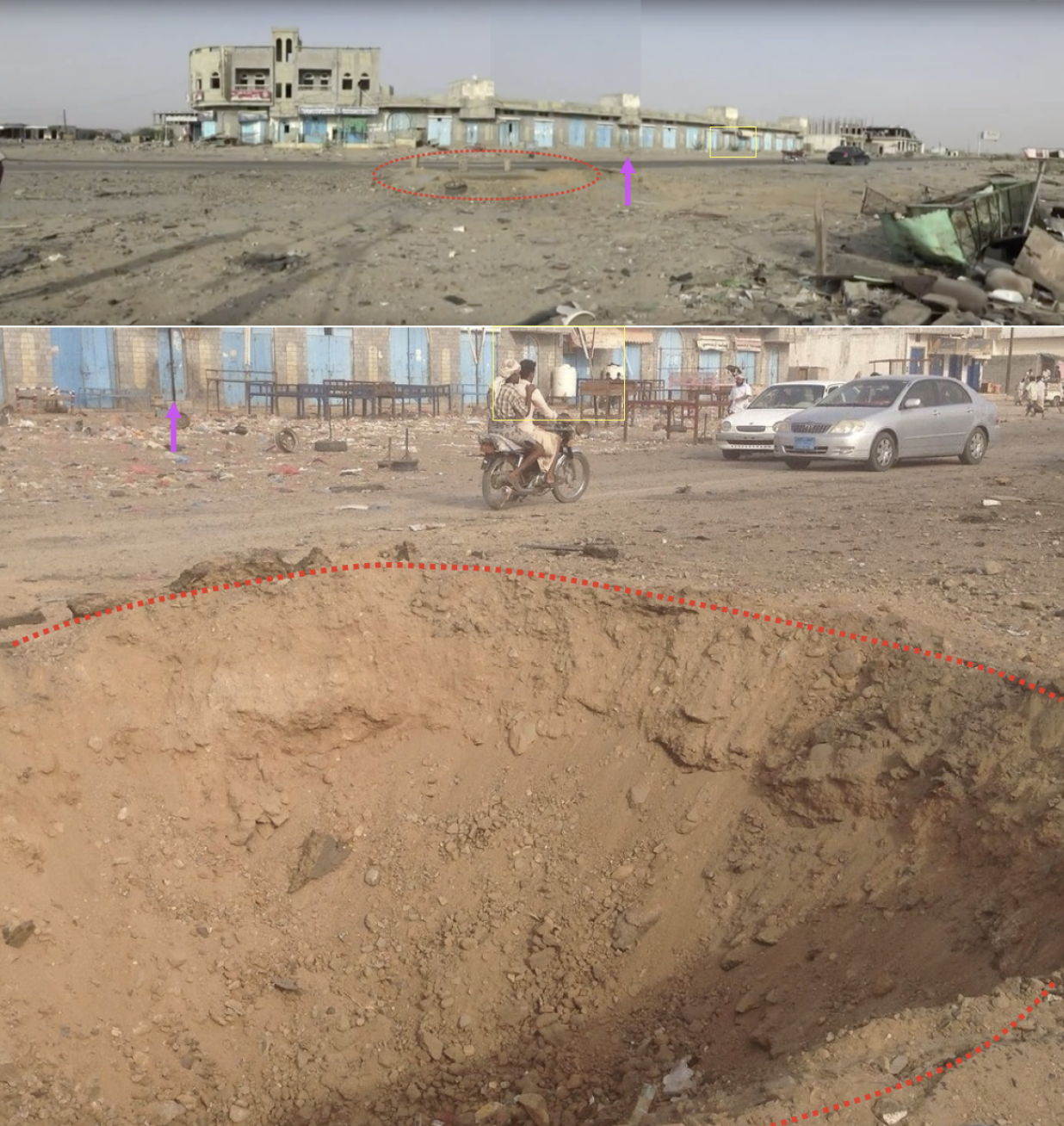
We can identify the exact location of the crater shown in news reports, posted on YouTube several weeks after the incident and in 2016, by building panoramas of both these videos and then comparing them to satellite imagery.
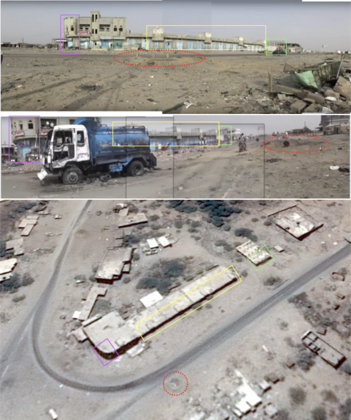
Comparison: Top – Youtube video of what appears to be a news report from this location commemorating one year after this incident (posted 2016-06-21). Middle – Youtube video of a news report on this incident (posted 2015-10-29), Bottom – Satellite imagery taken on 2015-04-09. Crater outlined in red (courtesy of Google Earth/Airbus)
Although the Youtube videos were taken some time after the event, the image MSF took of this crater also matches this location. This demonstrates that all these videos, the MSF image and the satellite imagery show the same crater – that caused by the attack on this location on 2015-07-04.
Top: Panorama of Youtube video, Bottom: MSF image
The location of this crater (16.325103, 43.089532) is in the middle of this market area and immediately across the road from what is marked as the Saana Restaurant on Google Maps. The colour of the doors and the presence of benches and tables outside the buildings indicates that they are restaurants.
Other locations
MSF reported in a Facebook post and report that:
“The attack at the market, called Aahem triangle, started at around 20:30 when a cooking- gas station was hit. Half an hour later a second attack in the heart of the crowded market followed”
However, open source reports and media filmed in Muthalith Aahim do not depict this “cooking-gas station” and focus on a single crater near the restaurants.
HRW reported that a witness had told them that:
“several hours earlier, there had been a strike on a gas station about two kilometers (1.2 miles) further north. Then, about an hour later, there was a strike on a football field about one kilometer (0.6 miles) away, and at the same time another strike on an empty building about two kilometers away”
HRW also included an image in their report claiming it was from Muthalith Ahim, when in fact it depicted two buildings in Harad, approximately 7 km to the north.
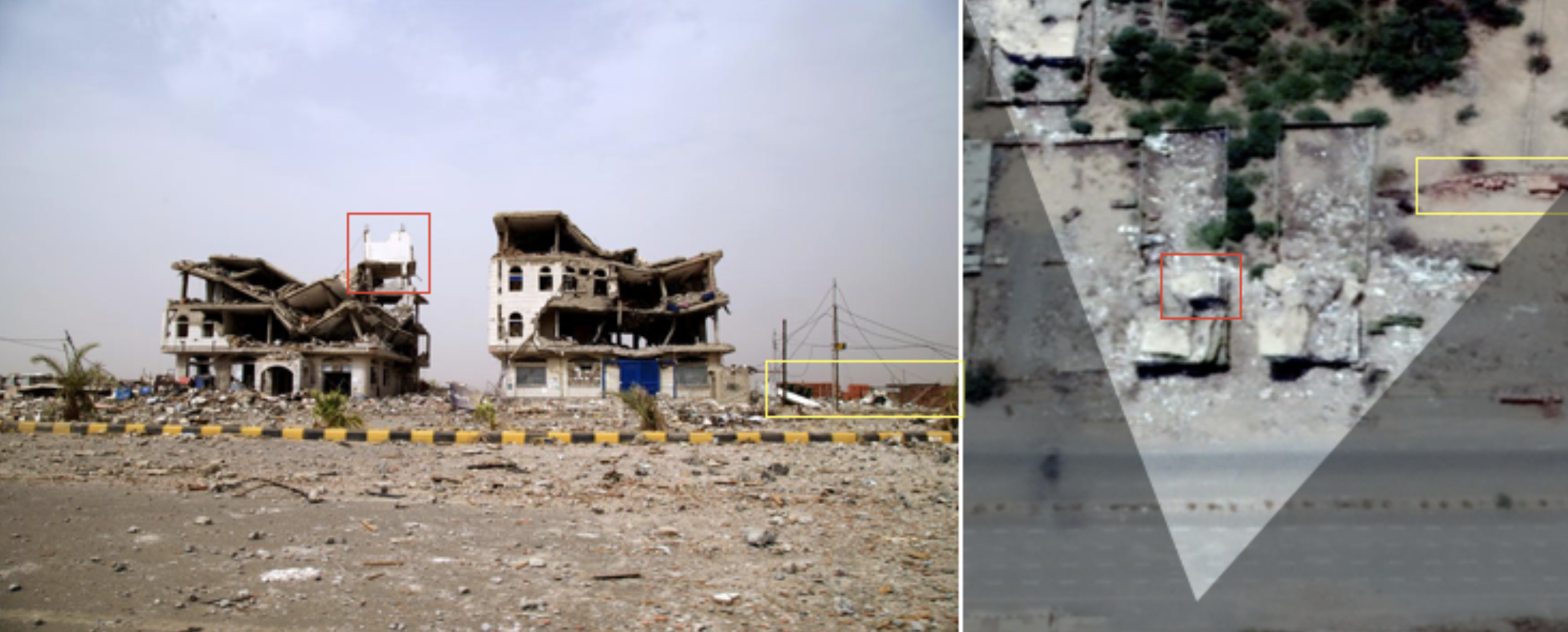
Left: HRW image claiming to be in “the village of Muthalith Ahim”, Right: buildings in Harad, approximately 7 km to the north of Muthalith Ahim (courtesy of Google Earth/DigitalGlobe, taken on 2019-27-7). Note that the pattern of destruction between the two images is the same.
We therefore believe that due to multiple strikes happening at around the same time, within the same 10 km radius, there was confusion over which locations had been hit. As outlined in this report, we could confirm only a single point of impact within Muthalith Ahim which resulted in mass civilian casualties.
What was this area used for?
The Muthalith Aahim is a nodal point on the route to and from the Saudi-Yemeni border which is approximately 20km to the north. Wikimapia, a crowd-sourced mapping service, and Google Maps indicate that the “triangle” includes a number of restaurants, a mosque and a clinic or hospital, which is also referred to in this news report. The MSF Facebook post claimed a hotel had also been hit, although these are likely to have been rooms for rent above the restaurants. The HRW report included a statement from one witness who said that the Huthis were operating a checkpoint in the area.
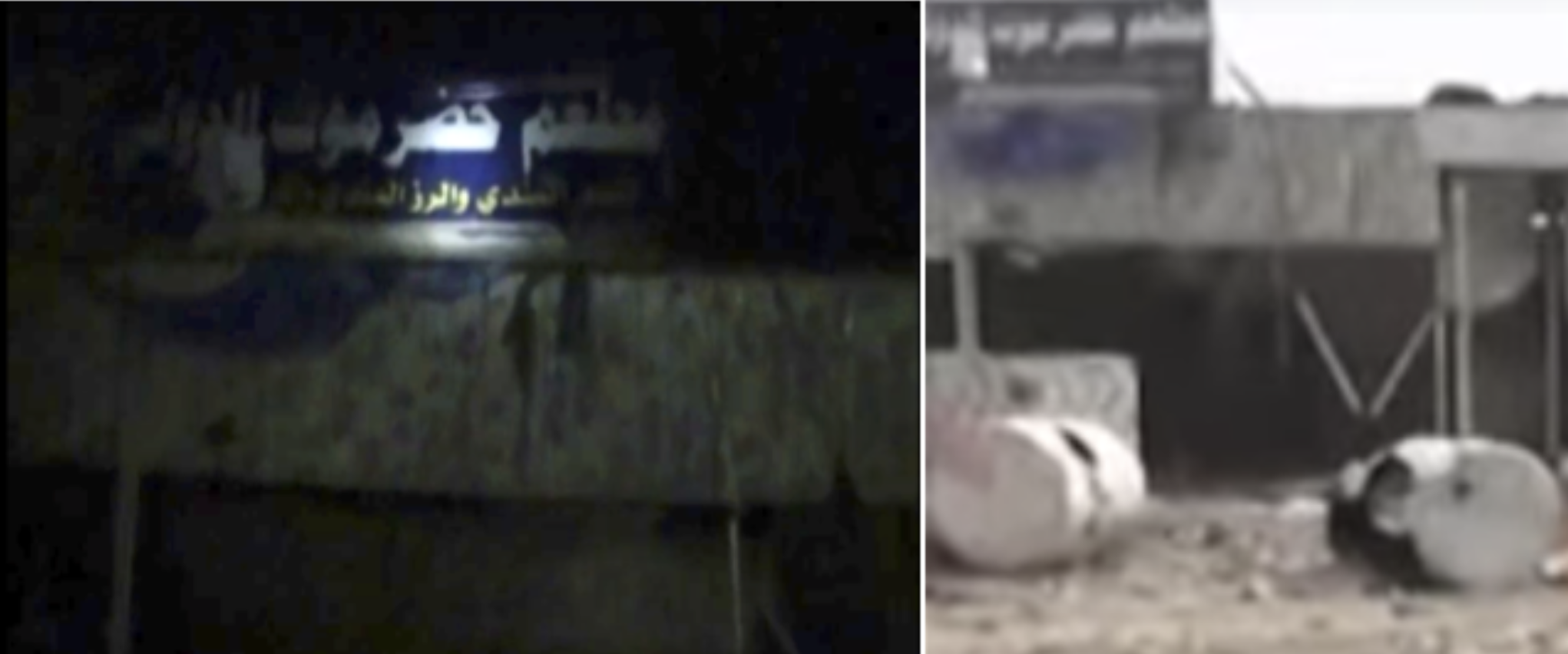
In the aftermath video of the event, a sign can be seen which reads “مطعم حضرموت”, ie: Hadhramaut Restaurant. This sign can be geolocated (see below) to the west side of the road, opposite the building which is marked as the Sanaa Restaurant.
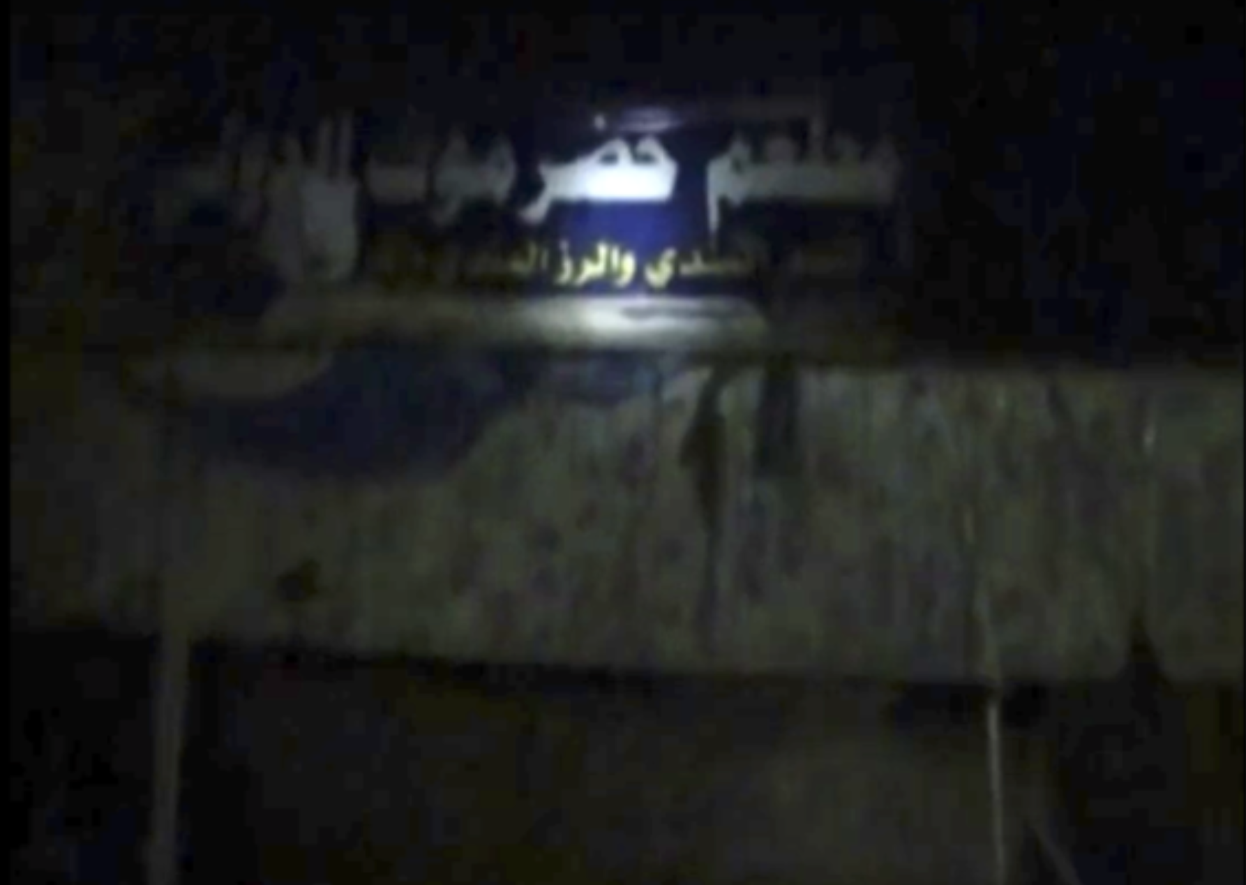
Still from aftermath video which shows a sign stating “مطعم حضرموت”, ie: Hadhramaut Restaurant. This still has been brightened to display the writing more clearly.
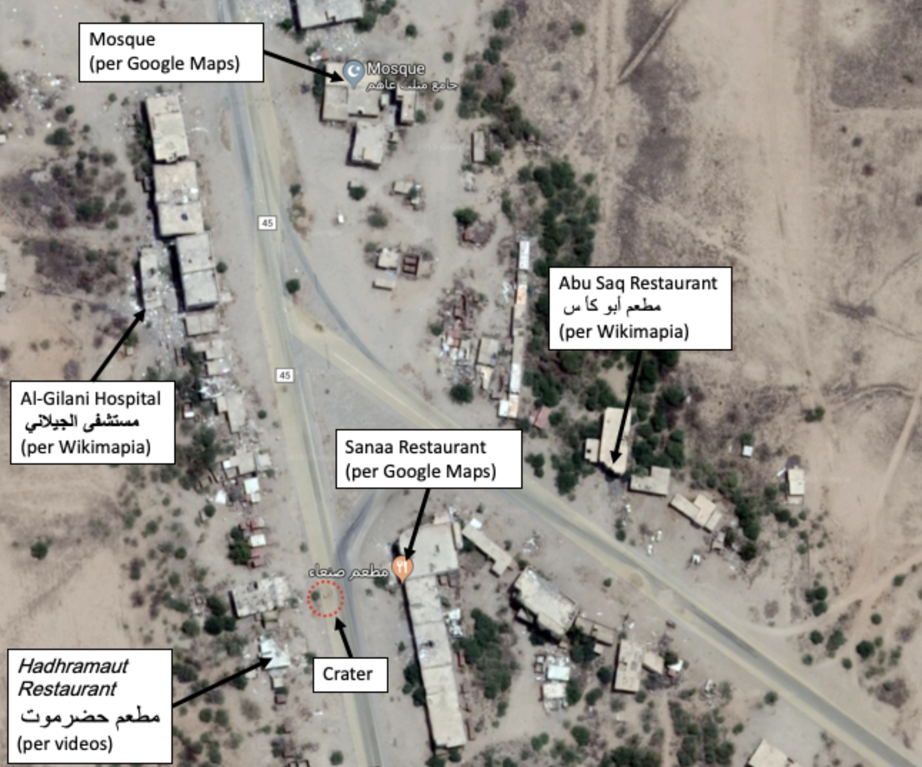
Image showing location of restaurants, Mosque, hospital and crater according to Google Maps, Wikimapia and open-source videos.
The HRW report states that the area outside the restaurants was also used by qat sellers, a fishmonger, vegetable sellers, and mobile phone merchants. The report also contains an interview from a witness who stated that there were also about 50–60 African migrants and IDPs from the Saudi/Yemeni border in this area at the time. It also states that the building which housed the Sanaa restaurant was four stories. Although it is difficult to establish exactly how many floors the building marked as the “Sanaa Restaurant’ on Google Maps has, its height certainly indicates that it could have three-to-four floors.
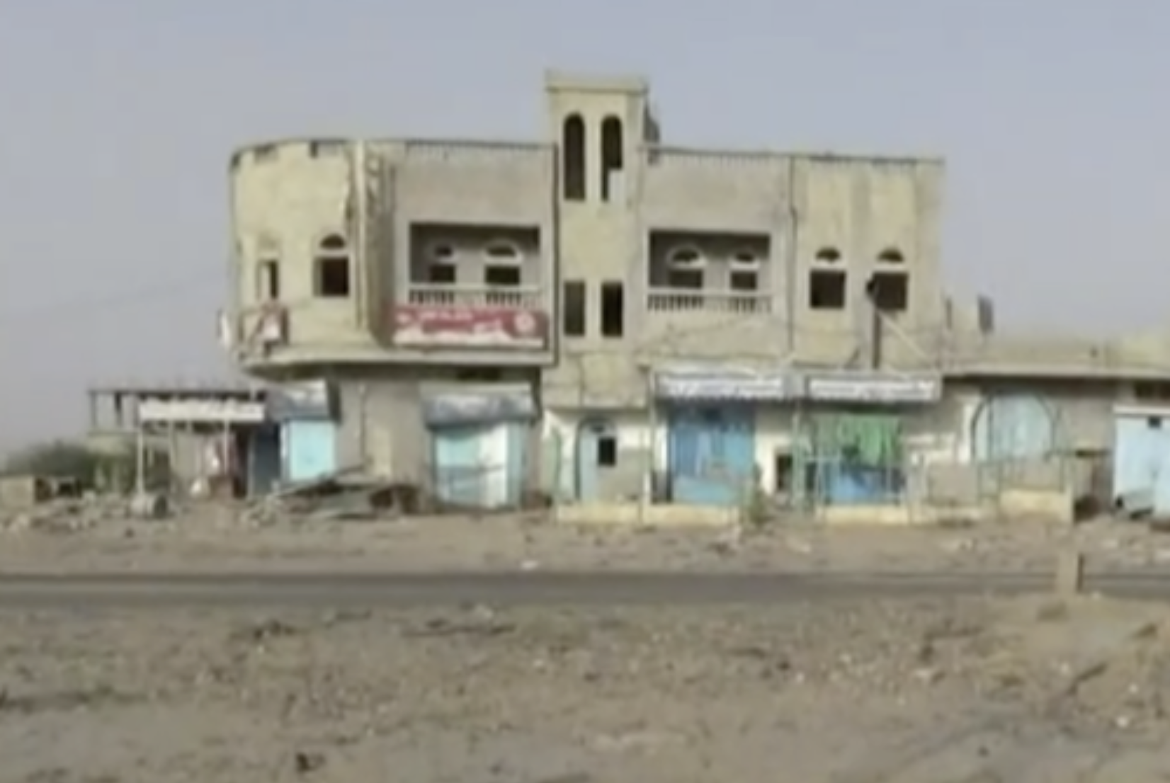
Still from this video showing the building marked as “Sanaa Restaurant” on Google Maps. It appears to be the tallest building within 100m of the crater.
Who was operating in the area?
The area is located within the governorate of Hajjah, which is a well-known stronghold of the Huthi movement and was considered to have been under their control at this time.
A truck driver named Salem al-Mashwali was interviewed by HRW and stated that Huthis were operating a checkpoint in the area, approximately 50 metres away from where the strike hit. This checkpoint was allegedly undamaged by the strike.
The area appears to be of strategic significance to both sides and it has been the target of repeated attacks before and after this incident. This Youtube video allegedly shows the aftermath of another strike on “Triangle of the Harad” several weeks (May 2015) prior to this strike.
WHEN?
Date
All open sources, including news reports, user generated content and NGO reports agree that the event took place on 2015-07-04. The earliest source is this aftermath video. Using the Amnesty International Youtube Data Viewer we can see that it was posted on 2015-07-05 at 22:04 UTC, or 2015-07-05 at 01:04 AST. This MSF article was posted on 2015-07-06 while this MSF Facebook post was made on 2015-07-08.
Time
The incident took place at about at 20:30 in the evening according to the MSF Facebook post and at “about 10:00 PM” according to the HRW report. It should be noted that the MSF report appeared very soon after the event (four days), while HRW got access to the site twenty days later. The Youtube video showing the aftermath of the attack is shot in darkness, which matches reports this incident took place in the evening.
The incident occurred during the month of Ramadan in the evening. During the month of Ramadan Yemenis tend to spend the day either asleep or reducing their activities significantly. Apart from eating, shopping in the market, socialising, and even travelling would take place after dark at that time of the year. It is wholly consistent that a large number of people, locals and travellers, would have congregated in the restaurants to continue eating into the night, having broken their fast after the dusk prayers at the nearby mosque.It should be noted that MSF reported the location as being a ‘busy marketplace’.
WHAT DAMAGE WAS DONE?
TO WHOM?
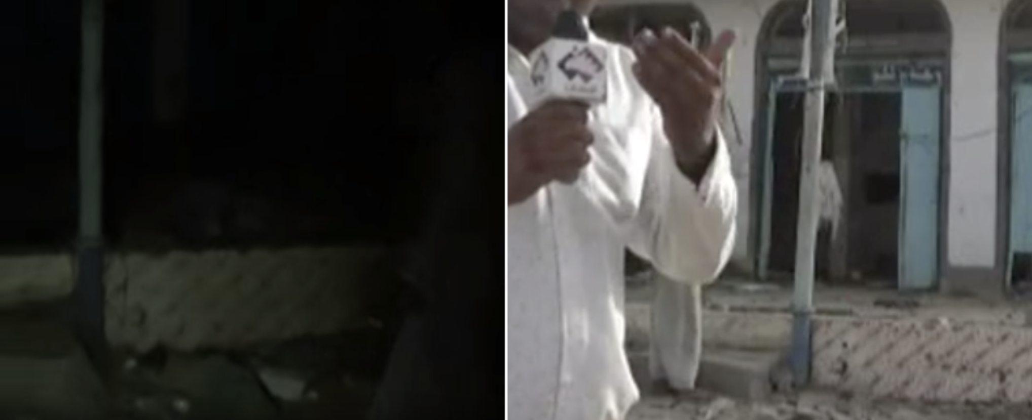
The people that appear in the aftermath video of the incident are dressed in civilian clothes and appear to be ordinary Yemenis. Nobody appears in a military uniform, however one of the interviewees appears to be wearing shoulder straps of some kind that appear similar to those of webbing or chest rig, along with what may be a radio antenna. Due to the very short length of this interview and the fact that it only shows a portion of his body, it is very difficult to be sure what these straps actually are.
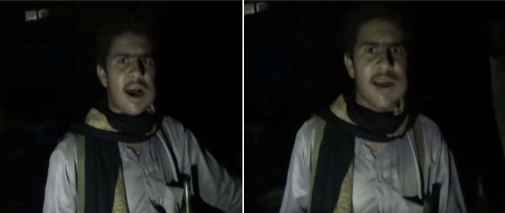
Still from the aftermath video at 03:49 showing a man wearing what may be some kind of chest rig
Although a person who may be armed is seen at 00:31 in the aftermath video, it should be noted that Yemenis traditionally carry arms as a sign of their tribal standing and seeing a person in civilian clothes with a rifle is not necessarily indicative of a person’s military status. Again, this section is too indistinct to be sure if this person is indeed armed.
The source of the video is “The Media Front Confronting the Saudi Aggression on Yemen” (الجبهة الإعلامية لمواجهة العدوان السعودي على اليمن). This is considered to be affiliated with the Huthis, who were in control of the area where the airstrike occured and they would have been first to respond at the scene. It contains video footage of possible aftermath of the scene of the second attack (market and restaurants) and several interviews with potential witnesses/victims.
Although it is filmed at night, we can be sure that this video depicts place where this incident took place. This is due to details that can be seen in the aftermath video which can be matched to details seen in later videos we know were taken at this location. Taking into account that the aftermath video was posted to Youtube on 2015-07-05 UTC 2204 UTC and that there were no mass casualty events previously reported at this location, it is almost certain that this video depicts the immediate aftermath of the incident.
Comparison – Left: Vehicle seen at 01:11 in the aftermath video, Right: Vehicle seen at the location of the incident in this video, also at 01:11.
Comparison – Left: Post and wall seen at 02:16 in the aftermath video, Right: Post and wall seen at the location of the incident in this video at 03:34
Comparison – Left: Sign seen at 01:47 in the aftermath video, Right: Sign seen at the location of the incident in this video at 00:30. Note the shape of the blue tarpaulin underneath the sign.
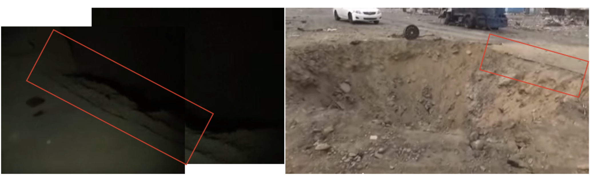
Comparison – Left: Crater seen at 01:04 in the aftermath video, Right: crater seen at the location of the incident in this video at 00:18.
We can therefore state with confidence that the aftermath video shows a large number of casualties were at the scene of this incident. All casualties appear to be young men and all were wearing civilian clothes. No weapons are evident among the debris.
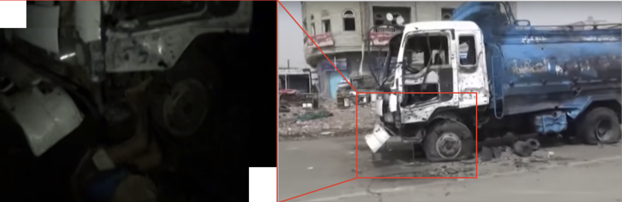
We can also see a pick-up truck and what appears to be some kind of water-tanker which appears to have been parked within a few meters of the munition impact point. The HRW report supports this conclusion, stating that a “water truck” had been destroyed.
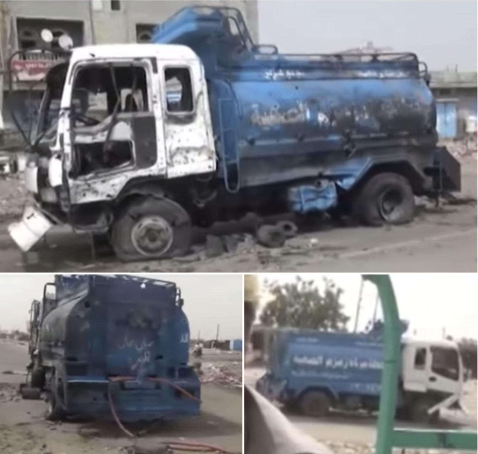
What appears to be some kind of water-tanker seen in this video. This is the same vehicle which can be seen at 01:11 in the aftermath video.
It should be noted that the hose pipe for this tanker is unwound. Although this could be because of the blast, or because people used the water to extinguish flames after the blast, it may also indicate that people were drawing water from this tanker when the incident occurred.
Number of casualties
The number of casualties reported for this attack varied:
HRW report: at least 65 fatalities, 105 wounded
LCRD report: 35 fatalities, >46 wounded
Shaharah news report: 30 fatalities
Ansarollah.com report: 30 fatalities
Al Methaq report: 30 fatalities
MSF report: ~20 fatalities, 67 wounded
In its report HRW included a list of 19 names of those killed or wounded from this incident, noting that that “rest of the list is available with Abs Clinic and Jumhouri Hospital in Hajja City.” This list of 19 names in below.
| Name | Gender | Age | Killed/Wounded |
| Abdul Salam al-Raimi | Male | over 18 | Killed |
| Abdullah al-Aawar | Male | over 18 | Killed |
| Faisal Ahmad | Male | over 18 | Killed |
| Bashir Ali | Male | over 18 | Killed |
| Abdu Ali | Male | over 18 | Killed |
| Muhammad Ahmad | Male | over 18 | Killed |
| Abdu Ali al-Raimi | Male | over 18 | Killed |
| Waddah Said | Male | over 18 | Killed |
| Shawki Ahmad | Male | over 18 | Killed |
| Ali Shuai | Male | over 18 | Killed |
| Majid Ali | Male | over 18 | Killed |
| Sultan Ahmad | Male | over 18 | Killed |
| Muhammad Hassan Hassan Abkar | Male | 35 | Wounded |
| Muhammad Ahmad al-Raimi | Male | over 18 | Wounded |
| al-Maslamani | Male | over 18 | Killed |
| His assistant | Male | over 18 | Killed |
| Faisal Ali Yusif | Male | 22 | Killed |
| Hassan Rabia Muhammad | Male | 27 | Killed |
| Abdul Wahid al-Zabidi | Male | 40 | Killed |
The LCRD also included a list of those killed and wounded in its report, including their ages and gender:
1. Omar Sultan Abdulwahid AL-Kuhlani 35 Male
- Bashar Abdulhafidh Muhammad Saleh 13 Male
- Haroun Muhammad Hadesh 20 Male
- Majeed Abdullah Muhammad 20 Male
- Wadhah Ali Muhammad Hadesh 30 Male
- Abdu Ahmed Sagheer AL-Ra’ei 45 Male
- Muhammad Hassan Hassan Abqar 38 Male
- Tariq Abdu Ali Ahmed 25 Male
- Abdussalam Abdullah Ali Saleh 42 Male
- Shayeef Jarmoush Ali 49 Male
- Mohammad Hassan Qassem 38 Male
- Jazem Ali Mohammed AL-Wessabi 20 Male
- Younis Hassan Muhammad AL-Naqeeb 20 Male
- Afif Adel Ahmed Emad 30 Male
- Saleh Mahyoub Ali Nasser 50 Male
- Hadi Ka’b Eid 47 Male
- Ali Sagheer AL-Tahami 50 Male
- Abdullah Othman Ahmed Saleh 25 Male
- Abdu Muhammad Ali Qassem 45 Male
- Taleb Ali Abdullah 40 Male
- Muhammad Abdu Ahmed AL-Jema’i 33 Male
- Ali Abdullah Ahmed AL-Sahbani 35 Male
- Abdullah Ali Nasser AL-Saleh 30 Male
- Mete’b Qassem Ahmed Mujalli 19 Male
- Shawqi Hamoud Ahmed Mutahar 42 Male
- Muhammad Ahmed Jua’eeri 45 Male
- Mustafa Farhan Hasssan Mansour – Male
- Omar Abqar Muhammad AIsh 19 Male
- Khalid Awadh Radman 25 Male
- Ali Ebraheem (Unconscious) – Male
- Hussein Hamoud Ali Ka’adas – Male
- Mahmoud Ali Hassan Abdullah 55 Male
- Yahya Zaid Abdu AL-Khameesi 35 Male
- Jalal Saleh AL-Soudi 35 Male
- Muhammad Muhammad Ebraheem Sa’eedi 32 Male
- Khalid Abdu Ahmed AL-Jaradi 28 Male
- Abdullah Ahmed Ali Hakami 18 Male
- Ali Muhammad Aman Khamees 25 Male
- Ahmed Ali Muhammad Shaqdouf 30 Male
- Abdullah Ahmed Bakili 2 Male
- Hassan Muhammad Ali AL-Ayssi 38 Male
- Esmaeel Muhammad Shoue’I Otaibi 25 Male
- Ali Shoue’I AL-Shaibani 28 Male
- Unknown Male –
- Unknown Male 35
- Unknown Male –
TO WHAT?
Reports of the incident and the video of the aftermant both point at significant damage having been done to the restaurants. The video shows a significant amount of rubble from the buildings strewn about mixed with victims’ bodies.
According to the HRW report:
“the airstrike destroyed at least six buildings along the main road of the village, including a four-story building housing the Sanaa Restaurant, a small shop and hotel, and a water truck and car parked outside.”
Analysis of videos after this strike indicate that the area has indeed suffered significant damage, and that a pick-up truck and water-tanker were destroyed. However, the building marked as the “Sanaa Restaurant” on Google Maps, on the east side of the road, appears to be structurally intact, although it is likely there was damage such as destroyed windows and other property.
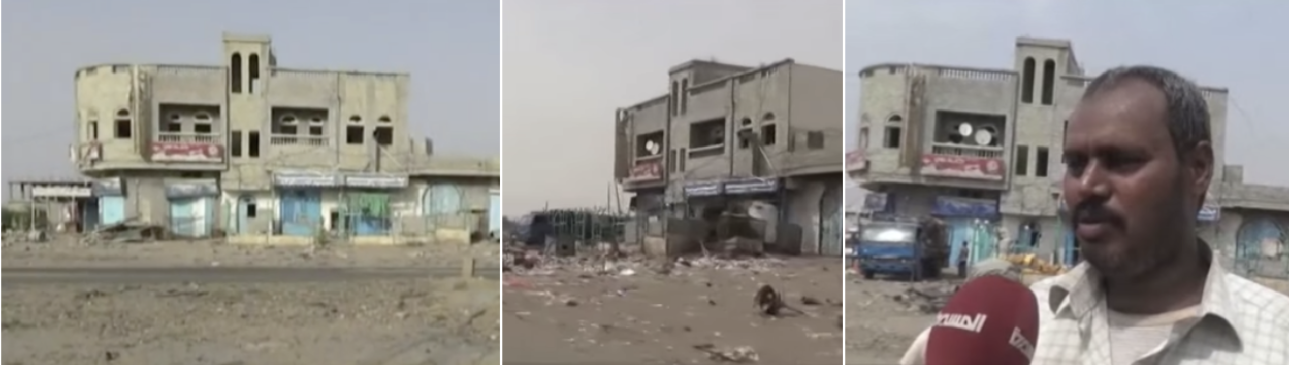
Stills from this video posted on 2016-06-21 (left) and this video posted on 2015-10-29 (right & right) showing the building marked as “Sanaa Restaurant” on Google Maps. Note that there does not appear to be significant structural damage.
The buildings on the west side of the road, including the Hadhramaut Restaurant, have clearly suffered significant structural damage. This is unsurprising considering they were closer to the crater than the buildings on the east side of the road.
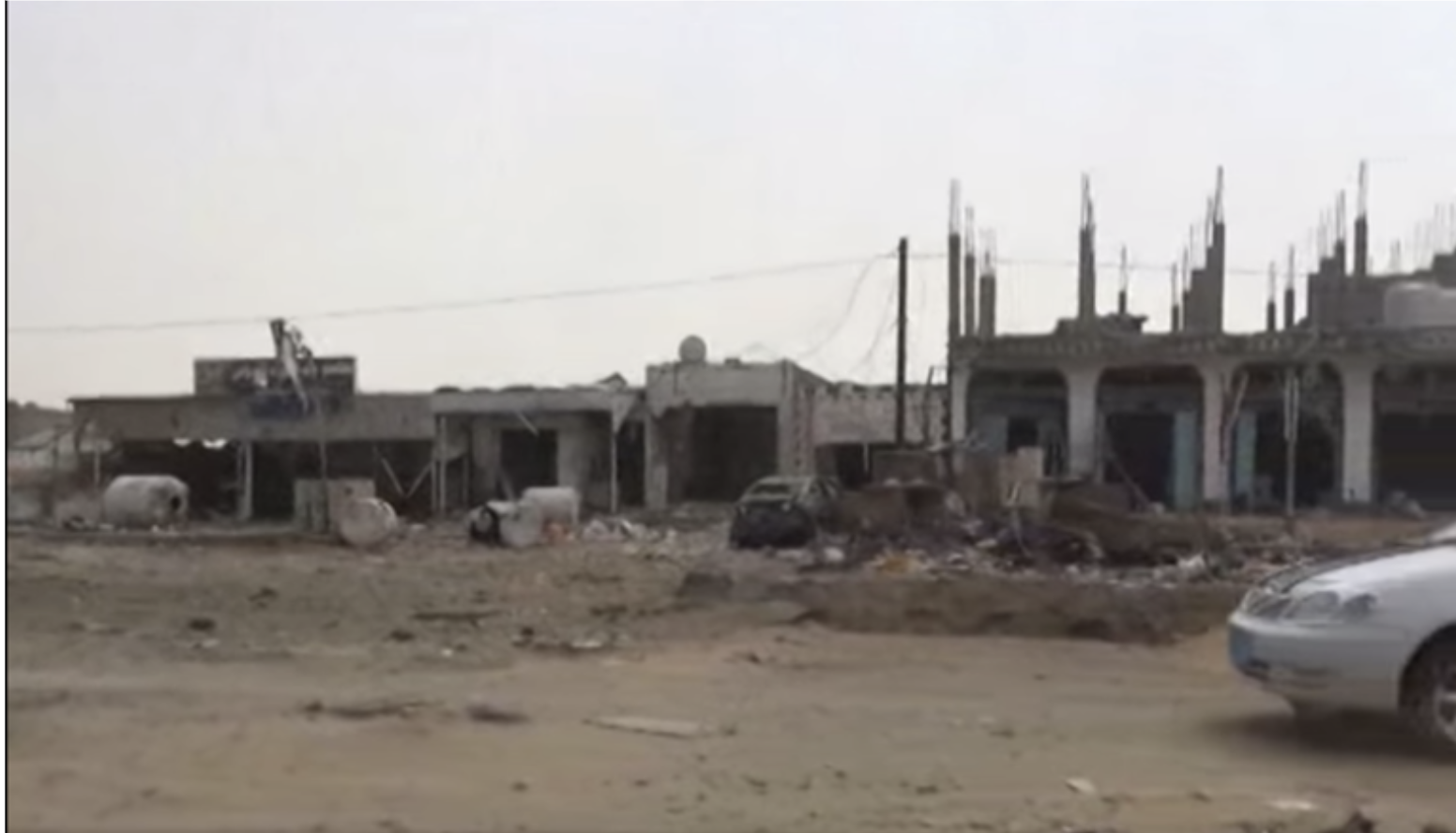
The still from this video posted on 2015-10-29 shows the buildings on the west side of the road and the damage that has been caused to them
WHAT MUNITION WAS USED?
The photograph of a crater published by MSF on Facebook on 2015-07-08 with a description of this incident on their website. An explosives expert working on the investigation confirmed that the size and shape of the crater indicates an airstrike, which could have injured dozens of people causing the casualties we listed below. There are no munition fragments visible in any of the material we have collected. It is therefore only possible to say that this crater picture below is consistent only with an air-dropped munition.
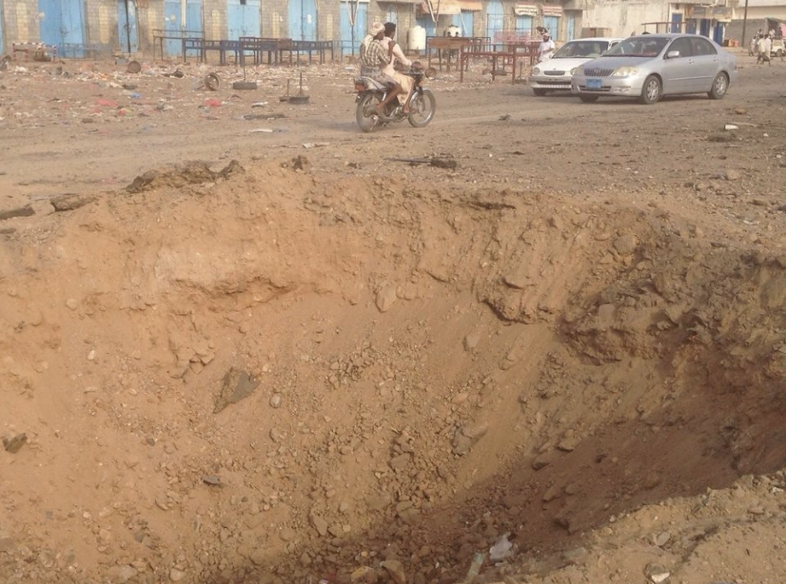
Image of crater posted by MSF
All reports point towards a series of airstrikes having taken place within a short period of time (an hour) in the vicinity of Harad and Muthalith Aahim. This may account for what sometimes appear as conflicting statements in reports that tend to conflate all these airstrikes into one event, or place the gas station in the Muthalith Aahim market.
It should be noted that multiple further airstrikes were reported in late July 2015. Satellite imagery also indicates that Muthalith Aahim was hit by multiple airstrikes after this incident, with clear structural damage across the market.
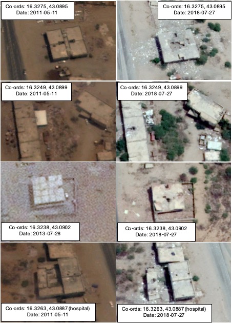
Damaged buildings in the vicinity.
WHAT DO PARTIES TO CONFLICT SAY?
THE SLC
The Joint Incident Assessment Team (JIAT) does not appear to have investigated this incident.
CONCLUSION
From the open sources available it is clear that on the night of 2015-07-04 a munition, most likely air-dropped, detonated in the middle of Muthalith Aahim, close to restaurants and a water truck. Video taken immediately after this event indicate that there were a significant number of casualties. The casualties depicted within these open sources all appeared to be civilians.