Debunking Maps of Alleged "Islamic No Go Zones" in London
Translations:
Various right-of-centre political commenters have, at different times, alluded to the existence of so-called “Islamic no go zones” in Western Europe. Generally, these are defined broadly and variously areas where the local authorities do not have effective police presence, a majority of the local population is Muslim, and “Sharia law” is in effect. Some commenters go as far to state that white people and/or non-Muslims are physically excluded, that there are borders and barriers, or else that Sharia patrols enforce them.
A wide variety of social media accounts and alt-right websites have alleged the existence of such zones in London. The author of this post devotes considerable effort to debunking such theories, as nearly every Londoner finds the very concept absurd. Numerous maps and articles have been posted, alleged to be “proof” or “evidence” of the existence of these so-called “Islamic no go zones.” This post is meant to serve as a resource debunking of such fake “evidence.”
Example 1: Tower Hamlets, Newham, and Waltham Forest
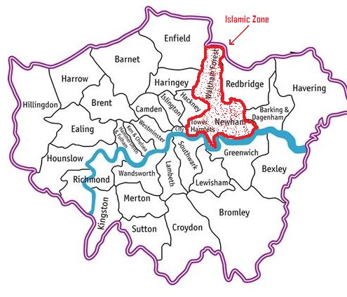
This particular map implies that three London Boroughs are actually no go zones and has been sent to me several times. Looking at published demographic statistics from government sources, the combined population of these boroughs is approximately 932,000 people. These are, indeed, some of the most heavily Muslim areas of the country. However, the combined three boroughs are approximately 30% Muslim. 70% of the shaded area is non-Muslim. Every major religion is present in these three boroughs, with literally hundreds of churches and a number of synagogues easily found through a simple Google search. How this area can be “Muslim only” when hundreds of thousands of non-Muslims live there and hundreds of thousands more commute to work in these areas is not explained. These figures, meanwhile, are approximate, given that the last census was in 2011.
All three boroughs have numerous outlets to sell alcohol, both for on premises and off premises consumption. For example, one can apply here for a licence to sell alcohol in Waltham Forest. The borough of Newham contains one of the largest shopping malls in London, an international airport, and was the site of numerous Olympic venues. The borough of Tower Hamlets contains the Tower of London (hence its name), visited by millions, and a very large banking district (Canary Wharf) which engages in non-Islamic finance (some financial institutions in Canary Wharf have branches or divisions that provide financial products compliant with Islamic finance practices in addition to their normal lines of business).
A brief internet search indicates that the above map actually comes from a far-right blog site called “British Nationalist.” It was posted in 2011.
(All of the links to odd far right sites in this post have been done through donotlink.it so as not to improve their position on search engine results)
Example 2: Tower Hamlets City of London Notice
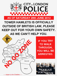
In early 2018, I was send this notice by three correspondents, claiming that it was an official police notice. This notice purports to notify people that, as of 29th June 2013, the London Borough of Tower Hamlets is a no go zone and that people will be arrested for entering it.
First of all, the tagline “Islam is for Cretins” should be an indicator that this is not a public document. More to the point, this fake notice relies on fundamental ignorance about policing in London. Many people outside of London do not realise that London has several police forces. The City of London Police is not the same thing as the London Metropolitan Police. The City of London Police only serve as the police in the one square mile region of The City of London, which is only a small part of greater London. The rest of London, including the area covered in this map, is under the jurisdiction of the Metropolitan Police. Whoever made this flier did not even grasp this basic fact.
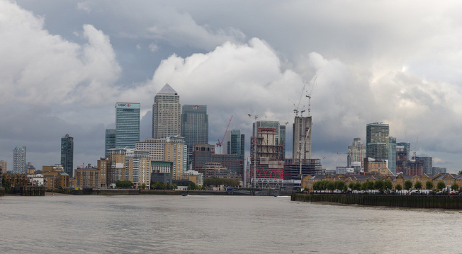
An interesting fact about this map is that it includes the entire Canary Wharf region, which is a very large financial district, as pictured below. (Photo courtesy R. Kaszeta)
A bit of internet research yields the interesting fact that this flier seems to have been circulated by a right-wing blog called “Gates of Vienna” (link) which in turn claims to have got it from someone’s Facebook page.
Example 3: The Acid Attack Map
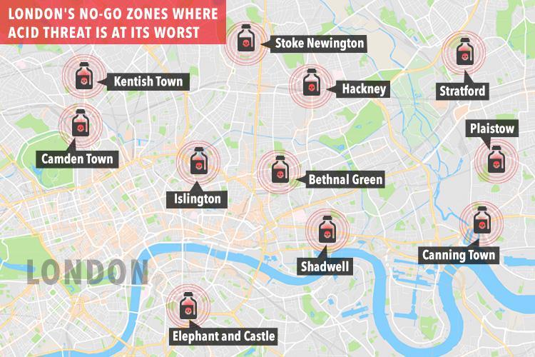
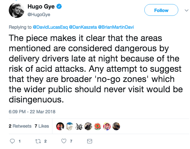
This map was originally published in the UK tabloid “The Sun” in December 2017 (here). The actual article, by Hugo Gye, talked about some moped delivery drivers having areas they preferred not to deliver to. However, this map has been taken out of context by many commentators who insist on misinterpreting it as picturing “Islamic no go zones.” For example, a right-wing blog called “Creeping Sharia” spread the map and used it imply that these areas of the city are somehow no go zones.
What we see here is a combination of two interesting trends. One is the conflation of caustic liquid attacks, erroneously called “acid attacks” (many attackers use caustic substances that are not, in fact, acids), with Islam. The BBC analysed the statistics on such attacks in a useful article. The majority of perpetrators are either white Europeans or of African/Caribbean descent. South Asians, a demographic category which includes many Muslims, are three times as likely to be the victims as opposed to perpetrators of “acid attacks”.” There’s no evidence tying this form of violence to sectarianism.
The other trend we have to understand is that ANYTHING labeled a “no go zone” will be appropriated by bigots, trolls, and misguided people for their own purposes.
Like the other maps, there is a level of absurdity to the claims that these areas are no go zones. Although this map does not define the catchment areas terribly well, a total of about a million people live in them. Many more commute there for work. One can look at the entry and exit statistics of Transport for London underground stations in the alleged no go zones depicted on the map. At Angel tube station, in the alleged no go zone of Islington, there were approximately 19,200,000 entries and exits from the tube station in 2017. The Camden Town tube station, clearly listed on the map as a “no go zone” had 22,510,000 entries and exits. Quite a bit of coming and going for alleged no go zones.
For live debunking of no go zones, the tfljamcams.net has live traffic cameras in every one of the alleged no go zones. You can see, any time of day or night, what really happens in these alleged no go zones — i.e. many different people, who are all going about their business.
The actual article in the Sun only focuses on a handful of moped delivery drivers. The words Islam and Muslim are not included in the article. Upon being contacted on Twitter, the author clearly explained that the article was not meant to indicate that these were Islamic no go zones for the general public.
Example 4: The Victoria Exclusion Zone
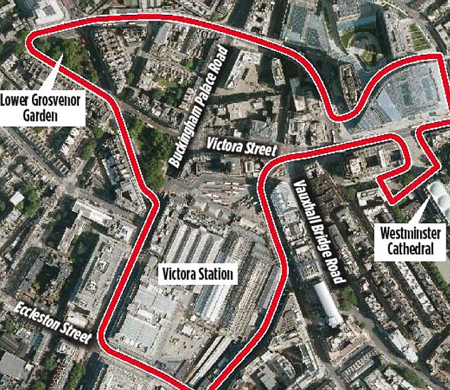
This is an interesting example. It claims to be from a news agency called “Juno News,” which turns out to be a strange blog as opposed to a news source. In fact, this map originally illustrated a local, temporary police measure against street begging, as reported in December 2013 by the Daily Mail. Instead of some no go zone, it was an area where a police officer had the temporary authority to ask someone begging on the street to move out of the zone.
One thing to note with this particular map is that “Victoria” is misspelled, both when it comes to Victoria Street and Victoria Station. Another thing to note, for those who have never been to London, is that Victoria Station is absurdly busy and is the main entry point in London for arrivals from Gatwick Airport. According to UK government statistics for the financial year 2016-2017, there were nearly 76 million entries and exits to the train platforms in Victoria Station. This does not even account the thousands of people who go through the station for other reasons, such as to go to the bus stops or tothe adjacent underground station.
Example 5: Westminster “No Go Zones”
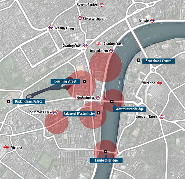
Finally, this map has been provided as an example of no go zones in the City of Westminster. It is actually a depiction of temporary exclusion areas immediately following the Westminster Bridge attack, where police investigations were ongoing. It is taken from a Daily Mail article in March 2017. These police advisories were lifted very quickly. None of these areas are exclusion areas. Several of these areas can be observed using live traffic camera footage, as explained above.
Overall Conclusions
When one delves beyond the realm of maps and dives into social media, there are clearly many other examples of claims of “no go zones” in London.Perhaps a future post can delve into these if there are sufficient interest. These examples cited above broadly cover the majority of the claims. Indeed, claims based on these maps are generally more detailed than many claims on Twitter, which often use vague terms like “East London” or absurd terms like “Eastern London” (nobody in London uses this term) or “Londonistan.”
Several general trends emerge upon examination. While some claims are fabricated entirely out of whole cloth, others take actual events and either draw odd conclusions or twist them out of proportion. The fact that the London Borough of Tower Hamlets had a Muslim mayor for some years led to odd claims that the area was under Sharia law, deliberately muddling the religion of the mayor with the legal framework of governance. The election of Sadiq Khan as Mayor of Greater London has furthered such claims.
In addition, isolated examples have been taken out of context and purported to be representative of widespread circumstances. For example, three extremists formed an unsanctioned “Sharia patrol” and harrassed people in Bethnal Green, Stepney, and Shoreditch (all areas in East London). These individuals were arrested, tried, and jailed. In another incident, the so-called “Ginger Jihadi” was jailed for similar conduct. Videos of both are routinely circulated as evidence.
The best way to debunk the “no go zone” phenomenon is to go to these areas and either observe or engage in conduct that is obviously not in accordance with strict application of Sharia laws. This author’s own efforts in this area have been well noted in the last year, as shown by this example and this one.