A Beginner's Guide to Geolocating Videos
Translations:
On the Brown Moses Blog I was frequently working on authenticating videos, and one very useful technique is using information in the video to confirm the location the video was filmed. In this article, I’ll explain some of the techniques I use to identify those locations, using tools available to anyone with a internet connection.
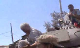
This first example shows how from a static position it’s possible to establish the precise location a video was filmed. On August 15th 2011, the Libya opposition claimed to have captured the small town of Tiji, posting the following video online as proof
The first 4 minutes of the video shows fighting in fairly featureless surroundings, but at 4:00 there’s a shot showing a street with buildings either side.
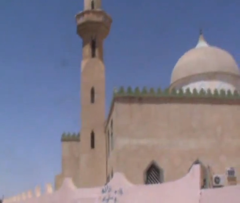
The first thing to look for are landmarks that might help narrow down the search, and on the same side of the road as the cameraman is a mosque
Tiji is a pretty small town, so there won’t be many mosques, but we can make our search even easier by looking for the kind of road the mosque is on
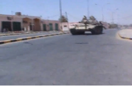
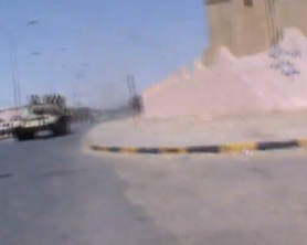
We can get a good idea what the road looks like from this shot. It has a small median, the lane closest to the camera is about two tanks wide, and has single story buildings across from the mosque.
Now to find Tiji on a map so we can take a look at the roads. A number of sites are available with satellite map imagery, including Google Maps and Bing Maps, but I find Wikimapia very useful as you can select different source satellite map imagery from Google Maps, Bing Maps, and Yahoo! Maps, which can be useful when one set of satellite map imagery isn’t very clear.
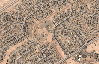
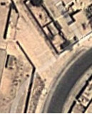
Finding Tiji is a simple enough search on Wikimapia, but in some cases with Arab countries you’ll only be able to find Arabic place names, something to keep in mind when searching for more obscure locations. Below we have a satellite view of the town
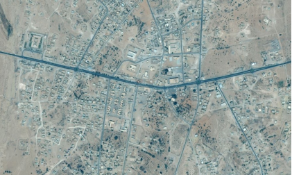
If we zoom in closer we can see that there’s a number of roads in the centre of the town, but only the main road running through the town appears to have a median
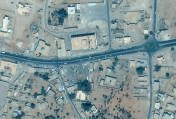
In fact, we can zoom in close enough to see individual cars on the road, which is clearly wide enough to accommodate at least two large vehicles, maybe even three, matching what we can see in the video
So we have a road that would see like a pretty good match to what’s in the video, and we know there’s a mosque on it, so all we have to do now is follow the road until we find a mosque.

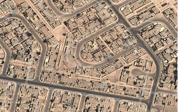
Now we have a mosque on the road, we can do more to confirm it’s the correct location. The most obvious feature is the minaret on the south side of the mosque, visible in the satellite map, and frequently a useful point of reference in videos from the Middle East. We can clearly see in the video that the minaret is on the side closest to the road (south), with the mosque’s dome to the right of the minaret (the north). It’s also possible to make out the wall outside of the mosque from the satellite map, and where the road curves northwards
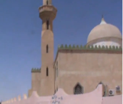
From this we can say the location is almost certainly here

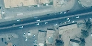
You’ll note to the south of the mosque, across the road, there’s also a number of trees, and these are visible in the background as the tank drives by
It’s also worth checking for any tall buildings in the video, as the satellite map appears to show no buildings that are taller than the mosque, and if there were that would suggest this is the wrong location.
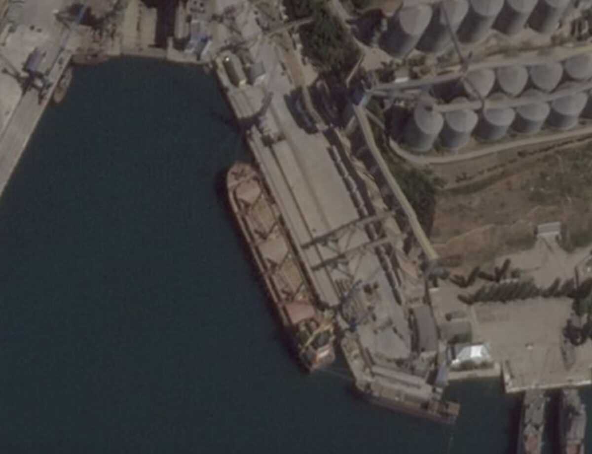
That’s a pretty straight forward example with a distinct landmark, and in a small town. This next video, from August 11th 2011, claimed to show the Libyan opposition taking control of the key town of Brega, with fighters taking a tour of a urban area
For a long time Brega was the front-line between the opposition forces based in Benghazi, and loyalist in the Gaddafi stronghold of Sirte. For months, there were constant reports of the opposition capturing the town, but very little evidence to support the claim. Brega itself is a mixture of small residential areas and industrial complexes, spread out over around 10km of coast line. From the video we can see the opposition are in a residential area, made up of rows of single and two storey buildings. This doesn’t match one of the three residential areas in Brega, which appears to be made up of multi-storey buildings that are spaced apart
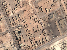
But it could match the western and eastern residential areas

While the buildings in the video are fairly featureless, there’s something else that we can work from that’s likely to be very unique. During the video, the cameraman walks around Brega, along the roads, and this means that from watching the video we can actually map out the roads. We can see he starts on a sharply curving road, at 42s he turns left, and shows the road he was on met a T-junction, and at 1:20 he comes to another junction. He turns left, walks past a junction on the right hand side of the road, and the road he’s on curves to the left.
But what are we looking for? Simply, the layout of the roads. We can see the roads, the way the curve in some areas, and where the junctions are. You can simply sketch it out on a piece of paper, which I’d recommend as it’s easier to rotate when you’re looking for a match, and then search the streets until you find a match. Here’s a very simple MS Paint sketch of the road layout

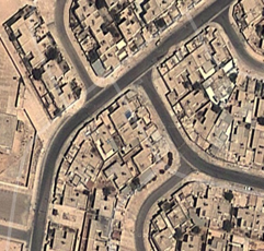
We can compare this to the two areas we’re looking at to see if there’s any matching pattern. The western residential area appears to lack the curving roads seen in the video, but the eastern residential area is a different matter
Now you take sketch of the road layout and see if there’s any matches in that area. In the eastern residential areas there’s one location that’s a match

To double-check the location is correct, you watch the video again, and check for anything that matches or doesn’t match. The area is fairly nondescript, but you can see some areas that match what’s in the video. For example, at 2:47, a long open area is visible behind the cameraman
As we know the route he’s walked, we can check the map if there’s an open area in the same position, and as we see below, there is
Currently, these are relatively unknown techniques, but as more and more unverified videos are produced from conflict zones, these kinds of techniques will be key part of the verification process.